Saskatchewan Bucket List: 10 Unmissable Things to Do
June 19, 2026
A practical Saskatchewan bucket list covering Grasslands, Prince Albert, Cypress Hills, Athabasca Sand Dunes, Lac La Ronge, Saskatoon, Regina, Big Muddy, Moose Jaw and Batoche.
What's on this page
Ten Saskatchewan experiences worth planning around, from dark-sky prairie and northern canoe routes to badlands, city river walks, mineral spas and Metis history.
Saskatchewan is the Canada people think is "just flat", and the province that absolutely proves them wrong: rolling hills, dark-sky parks, canoe routes through rock and pine, wild sand dunes, and cities wrapped around big rivers and lakes. Distances are manageable, stories run deep, and the skies really are so big that watching clouds can qualify as an activity.
Here's a Saskatchewan bucket list of 10 unmissable things to do, written so you can use it mid-road-trip.
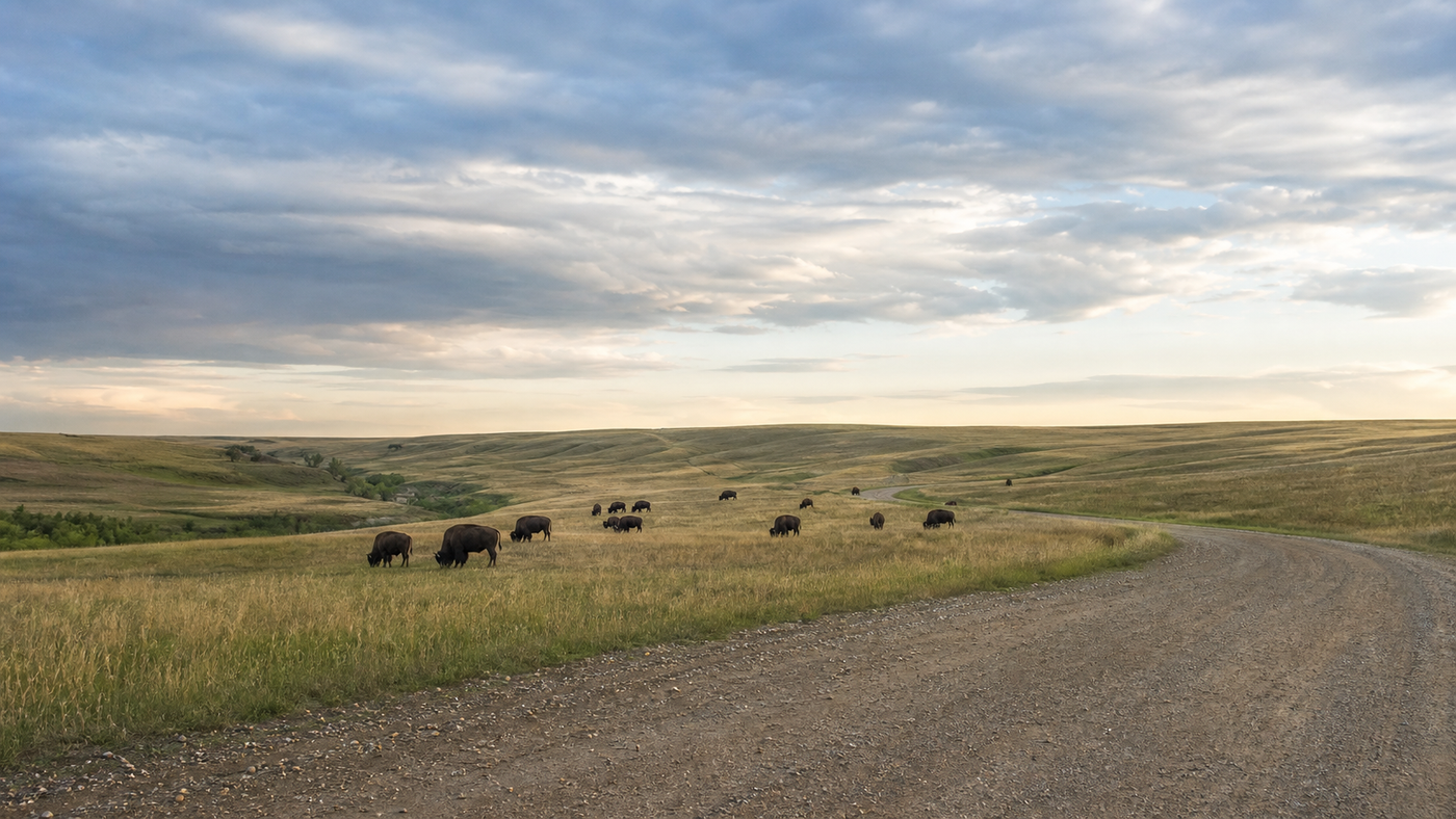
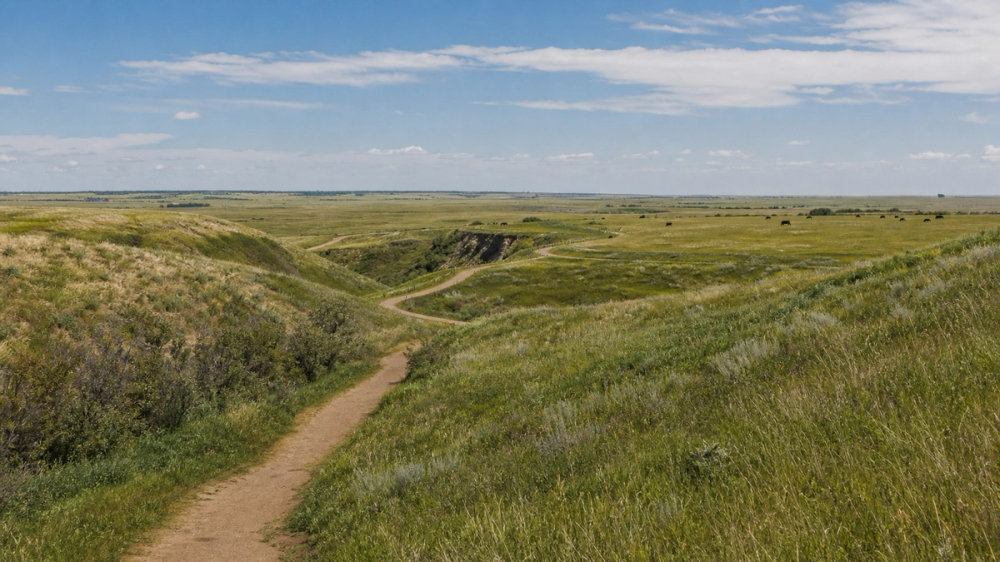
Chase stars and bison in Grasslands National Park
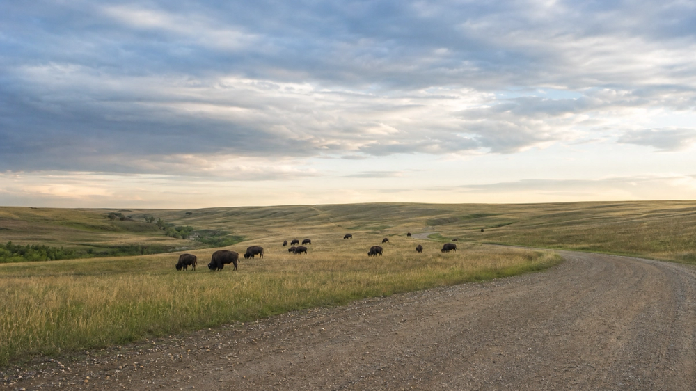
Down along the U.S. border, Grasslands National Park preserves one of the last intact stretches of mixed-grass prairie in North America. It's a place of huge horizons, shortgrass waving in the wind, and wild herds of plains bison that often graze so close to the road you'll be whispering "are we allowed to be this near?" through the car window. This is also Canada's only home for black-tailed prairie dogs, whose busy little towns flank the park roads and trails.
The park has two main sections, the West Block near Val Marie and the more remote East Block near Killdeer, linked by a 90-minute drive. Scenic drives and day hikes thread through coulees, buttes, and wide open grassland, and the quiet is almost shocking if you're coming straight from a city. At night, Grasslands really lives up to Saskatchewan's "Land of Living Skies" slogan: it's officially one of the darkest Dark Sky Preserves in Canada, with Bortle Class 1 skies where the Milky Way is bright enough to cast shadows on the ground.
Good to know
- Best view: Any pullout on the Ecotour Scenic Drive in the West Block at sunset and again after dark, when the sky switches from pink to full-on galaxy.
- Wildlife timing: Bison, pronghorn, deer and prairie dogs are most active around dawn and dusk, so plan slow drives at those hours.
- Logistics: There are no big towns within ~100 km, so top up fuel in Val Marie or nearby communities and bring food, water, and layers.
Paddle and hike among lakes in Prince Albert National Park
In central Saskatchewan, Prince Albert National Park feels like a northern cottage country that never quite got around to over-developing itself. The resort town of Waskesiu Lake is the park's hub, with hotels, cabin rentals, campgrounds, beaches, and a small main street of cafes and shops right on the water. From here, roads and trails radiate out to long sandy beaches, spruce and aspen forest, and quieter lakeside viewpoints.
The park is built for slow days: swim and paddle on Waskesiu Lake, detour along the Narrows Peninsula or Waskesiu River trails, or drive north to smaller lakes for short walks and picnic spots. If you like your history with a side of canoe, a multi-day paddle to Grey Owl's cabin on Ajawaan Lake lets you visit the remote log home of the early 20th-century conservationist, now a bit of a pilgrimage for canoeists. Even if you stay close to Waskesiu, evenings on the beach with loons calling and a slow northern sunset are hard to beat.
Good to know
- Best view: Late-day light over Waskesiu Lake from the main beach or one of the lakeside points, forest and sky reflected in calm water.
- Trail sampler: Try the Waskesiu River Trail for an easy loop along a meandering river and through spruce forest, or Narrows Peninsula for lake views and ferns in early summer.
- Base: Waskesiu townsite has everything from campsites to cabins and hotels, plus restaurants and gear rentals, so you can park the car and stay put.
Look up at the universe in Cypress Hills Interprovincial Park
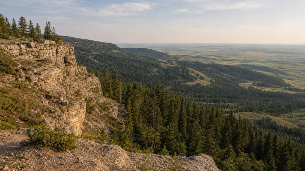
Down in the province's southwest, Cypress Hills Interprovincial Park pops unexpectedly out of the plains: a high plateau of lodgepole pine, lakes, and rolling meadows shared between Saskatchewan and Alberta. Because the hills rise well above the surrounding prairie, the air feels cooler and the views stretch forever from lookouts like Bald Butte, Lookout Point, and the Conglomerate Cliffs.
Cypress Hills is officially a Dark Sky Preserve and is known for some of the clearest, darkest, and most accessible night skies in Canada. In the Saskatchewan Centre Block, an observatory and regular public programs make stargazing feel less like guesswork and more like "oh, so that's what that constellation actually looks like." By day, you can hike or ride sections of the Trans-Canada Trail, paddle or swim on Loch Leven, zipline through the trees with Treeosix Adventure Parks, and sample local fruit wines at nearby Cypress Hills Vineyard & Winery.
Good to know
- Best view: Conglomerate Cliffs or Horseshoe Canyon near sunset, looking out over waves of hills fading into the prairie; stargazing from the observatory field at night.
- Activities: Hiking, horseback riding, paddling, swimming, disc golf, ziplining, winter snowshoeing and snowmobiling - it's very much a "choose your own adventure" park.
- Stargazing tip: Plan around the Saskatchewan Summer Star Party or a new-moon weekend if you want maximum Milky Way drama.
Fly into another world at Athabasca Sand Dunes Provincial Park
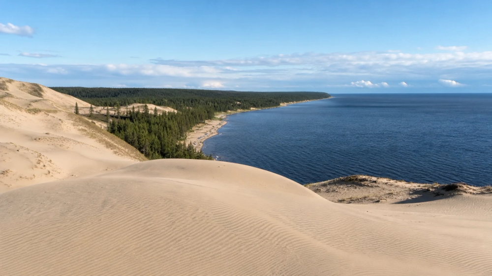
In the far north, along the south shore of Lake Athabasca, lies one of Saskatchewan's strangest landscapes: the Athabasca Sand Dunes. These are some of the largest active sand dunes in Canada, with dunes up to 30 metres high stretching for about 100 km along the lake, punctuated by small lakes, rivers, and rare plants found nowhere else. It looks more like a slice of the Sahara grafted onto boreal forest than anything you expect in the Canadian Shield.
This is not a casual detour. Athabasca Sand Dunes Provincial Park is accessible only by floatplane or boat, with no roads, no services, and very little in the way of infrastructure. Visitors typically base out of communities like Stony Rapids or Fond-du-Lac and arrange air or boat transport into the park, camping on the sand or in the sparse vegetation behind the dunes. The reward is utter remoteness: walking ridge lines of pale sand above dark water, tracing wind ripples and animal tracks, and feeling very small in the best possible way.
Good to know
- Best view: A high dune ridge overlooking Lake Athabasca or the Archibald River, with sand waves dropping away on one side and forest or water on the other.
- Who it's for: Experienced backcountry travellers comfortable with full self-sufficiency, navigation, and leaving no trace in a fragile, remote environment.
- Planning: Trips require serious advance planning, park permits, and weather flexibility; this is a "trip of a lifetime", not a last-minute weekend idea.
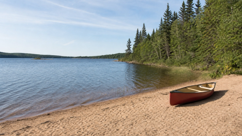
Thread the islands and routes of Lac La Ronge Provincial Park
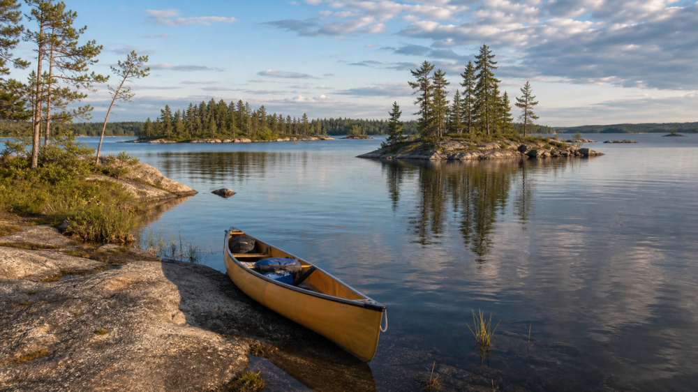
North-central Saskatchewan's Lac La Ronge Provincial Park is a maze of water and rock: nearly 100 lakes and more than 30 mapped canoe routes, many following old fur-trade corridors through the Churchill River system. The main hubs around Lac La Ronge itself - Nut Point, Nemeiben, Wadin Bay and Missinipe - offer campgrounds with varying levels of service, boat launches, and sandy beaches, but it doesn't take long to leave the crowds and find your own island.
Paddlers come here for multi-day trips linking lakes and rivers, often with short portages around falls or rapids and evenings on granite points under tall spruce. Fishing for pike, walleye, and trout is excellent, and backcountry sites along the Churchill River feel properly wild without being impossible to reach. If you're not up for a full expedition, base yourself in a front-country campground and do day paddles to nearby islands or short hikes to viewpoints - you still get the feel of the north without committing to a full gear list.
Good to know
- Best view: Evening on an island campsite or day-use point, looking out over scattered islands and sunset light on the water.
- Canoe routes: With 30+ documented routes and outfitters in places like Missinipe, you can pick anything from a gentle overnight to a week-long odyssey.
- Season: Full services typically run May to early September; outside those months, expect limited facilities and colder, rougher water.
Walk river trails and learn at Wanuskewin in Saskatoon
Saskatoon is built around the South Saskatchewan River, and its best introduction is a walk or ride along the Meewasin Valley Trail that traces both banks. The path runs over 60-100 km in and around the city, ducking under bridges, through parks like Kiwanis Memorial Park and Victoria Park, and past downtown landmarks and viewpoints. Recent upgrades near the Delta Bessborough hotel added wider promenades, benches, lighting, and new lookouts over the river, making it an easy "I'll just go for a quick walk" trap.
A short drive north of town, Wanuskewin Heritage Park is one of Saskatchewan's most important cultural sites. Archaeological evidence here shows nearly 6,000 years of continuous Indigenous use, and the park has been placed on Canada's tentative list for UNESCO World Heritage status. Trails loop through grassland, coulees, and bison pasture, while the visitor centre hosts exhibits, art, and programming focused on the cultures and histories of the Northern Plains Indigenous peoples. It's an essential stop if you want your Saskatchewan trip to be about more than just pretty skies.
Good to know
- Best view: Evening along the Meewasin Trail downtown, with the river reflecting bridges and the city skyline as the lights come on.
- Wanuskewin highlights: Walking the valley trails, seeing bison on the hillsides, and spending unhurried time in the exhibits and cultural spaces.
- Orientation: Saskatoon and Regina are about 260 km / ~3 hours apart by road, so it's easy to stitch both cities into one loop.
Circle the lake and gardens at Regina's Wascana Centre
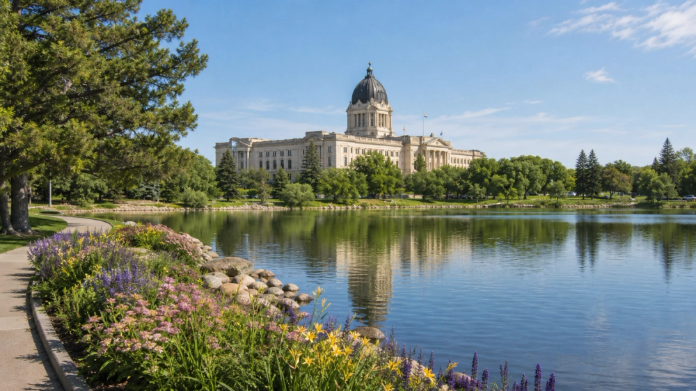
Regina, the provincial capital, wraps itself around Wascana Centre, a 930-hectare urban park built around Wascana Lake and designed around the Saskatchewan Legislative Building. Paths circle the water, passing the domed Legislature, gardens, and major institutions like the Royal Saskatchewan Museum, Saskatchewan Science Centre, and the Conexus Arts Centre. On summer evenings, joggers, dog-walkers and picnickers give the whole area a very "yes, people really live here" energy.
The Legislative Building itself is worth a tour, both for the ornate interior and for the view back across the lake from its steps or the nearby bridges. In winter, the whole scene shifts: cross-country ski tracks appear in the park, and snow muffles the city to the point where standing by the lake at night feels surprisingly serene. Beyond Wascana, Regina's downtown and Warehouse District add cafes, restaurants and small venues, but the lake is where you go when you want to remember the city has space to breathe.
Good to know
- Best view: The classic Legislative Building across Wascana Lake, framed by flowerbeds in summer or snow and the equestrian statue of Queen Elizabeth II and Burmese in winter.
- What to pair it with: A visit to the Royal Saskatchewan Museum for natural history and Indigenous exhibits, or the Science Centre if you have kids.
- City pairing: Combine Regina with Moose Jaw and Cypress Hills for a south-central loop of spas, tunnels, and hills.
Scramble around outlaw history in the Big Muddy Badlands
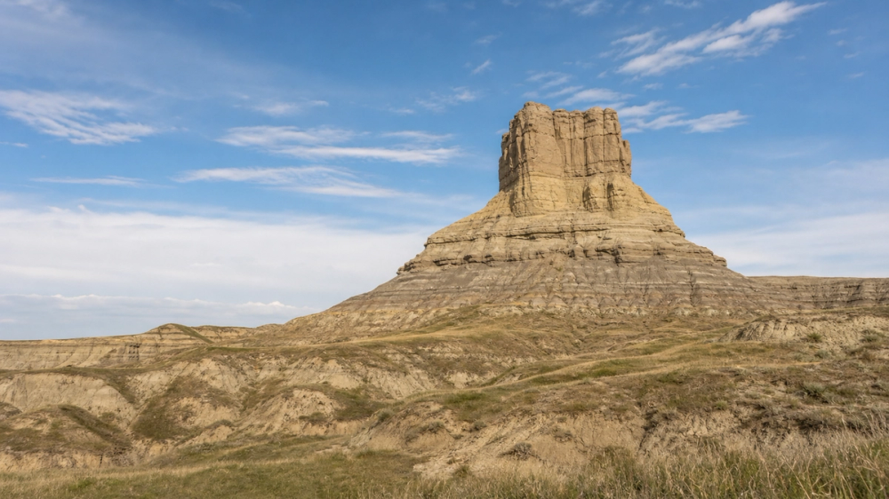
In the province's deep south near Coronach, the Big Muddy Badlands carve a series of buttes, ravines, and sandstone formations out of what most people think of as "flat prairie." These rugged hills and hoodoos were once hideouts for outlaws like the Sundance Kid and Dutch Henry, whose cross-border horse-thieving made full use of the landscape's blind spots. Today you can tour former hideout caves, gaze up at steep buttes, and spot ancient Indigenous effigies carved into the land.
The star of the area is Castle Butte, a huge, isolated clay and sandstone outcrop rising about 60 metres above the surrounding plain. Short, informal trails let you circle and climb sections of it, rewarded with big-sky views over the badlands in every direction. Guided tours run out of Coronach and cover multiple sites in one long loop, filling in both the human history and the geology that shaped this pocket of the province.
Good to know
- Best view: On top of or beside Castle Butte, with layered buttes and coulees unrolling into the distance under a huge sky.
- How to visit: The Town of Coronach coordinates long and short Big Muddy tours by bus, van, or private vehicle that link caves, effigies, and viewpoints.
- Season: Tours mainly run May through September, with daily departures in July and August.
Soak and go underground in Moose Jaw
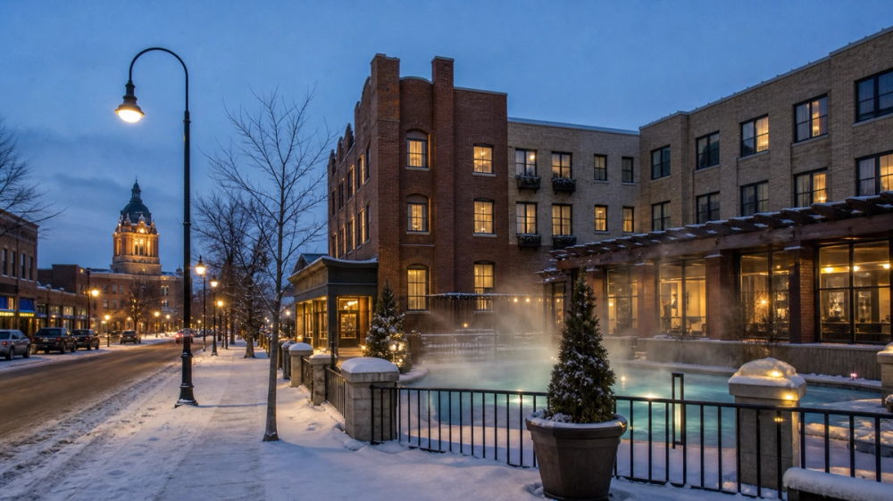
Moose Jaw looks like a classic prairie railway town at first glance: brick downtown, broad streets, and murals on building walls. Stick around and it gets weirder in good ways. The Tunnels of Moose Jaw are theatrical guided tours through a network of underground passages that dive into the town's Prohibition-era connections and Chinese immigrant history, complete with costumed guides and a fair amount of dramatization. It's touristy, sure, but also oddly educational and an easy way to fill a couple of hours.
Above ground, the main reason many people overnight in town is the Temple Gardens Hotel & Spa, whose claim to fame is a large geothermal mineral pool on an upper floor fed by hot water pumped from a well outside town. You can soak indoors or drift outside into a steaming open-air pool even when the air temperature is well below freezing, which is really the correct way to experience a prairie winter evening. Add a walk through the compact downtown and you have a very manageable, satisfying stop.
Good to know
- Top experiences: A tunnel tour, followed by an unreasonably long soak in the Temple Gardens mineral pool.
- When to go: The spa works year-round, but winter soaks with falling snow are particularly smugness-inducing.
- Pairing: Easy to combine with Regina and Buffalo Pound Provincial Park for a short southern loop.
Stand on historic ground at Batoche National Historic Site
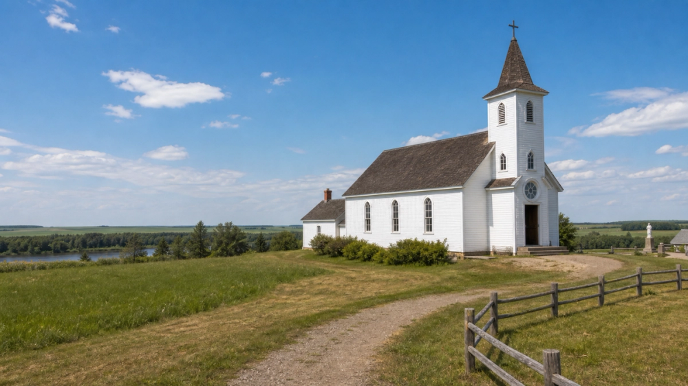
Batoche, on the banks of the South Saskatchewan River between Saskatoon and Prince Albert, is one of the most significant historic sites in Western Canada. This was the de facto capital of Louis Riel's Provisional Government of Saskatchewan and the site of the Battle of Batoche in May 1885, where Metis and First Nations fighters faced Canadian forces in the last pitched battle on Canadian soil. For many Metis, it remains a sacred place of resistance and renewal.
Today, Batoche National Historic Site preserves the 1885 church of St. Antoine de Padoue and its rectory, a restored Metis homestead, sections of rifle pits, and a visitor centre with exhibits and multimedia presentations about Metis life and the events of 1885. Costumed interpreters in season help bring everyday 19th-century life into focus, and trails lead along the river and past key battlefield points. Each July, Back to Batoche Days turns the site into a major cultural gathering, with thousands of people coming together to celebrate Metis culture, music, and community.
Good to know
- Best sense of place: Walking the rifle pits and riverbank with the interpretive map in hand, then stepping into the church and cemetery that have anchored the community for over a century.
- Timing: The site is generally open mid-May to mid-September, with full programming in peak summer; check dates if you're aiming for Back to Batoche Days.
- Getting there: About an hour's drive north of Saskatoon, making it an easy day trip combined with stops at nearby St. Laurent or other river communities.
Saskatchewan rewards anyone willing to leave Highway 1 and actually go where the horizon is doing something interesting. Between dark-sky grasslands, northern canoe routes, outlaw badlands, and cities built around rivers and lakes, you get plenty of chances to prove to yourself that "just flat" was never the full story.
Related travel guides:
Page details
Author: Canooq Editorial
Updated: June 19, 2026
Last reviewed: June 19, 2026
Sources verified: June 19, 2026
Cite this page: Canooq.ca, Saskatchewan Bucket List: 10 Unmissable Things to Do, https://www.canooq.ca/travel/saskatchewan-bucket-list
Canooq content is educational and may include affiliate or referral links. It is not financial, tax, legal, immigration, employment, mortgage, real estate, or healthcare advice. Verify official sources and provider terms before acting.