22 Unforgettable Views in Canada Worth Planning a Trip Around

June 23, 2026
A coast-to-coast guide to 22 unforgettable Canadian views, from Moraine Lake and Spirit Island to Signal Hill, Perce Rock, Toronto Islands, Yellowknife aurora and Auyuittuq.
What's on this page
Twenty-two Canada-wide viewpoints worth building a trip around, with practical notes on access, seasonality, hikes, reservations, nearby food stops and route planning.
Some views are built for a quick photograph. Others change your walking speed. You stop, look up properly, maybe forget the coffee in your hand, and stay put until the light shifts again. Canada has a scandalous number of those places: glacier-fed lakes in the Rockies, salt-sprayed headlands in Atlantic Canada, city terraces made for long twilight strolls, northern tundra that turns gold at summer’s edge, and aurora nights that can make a parking lot feel like a holy site if the sky decides to cooperate. This guide keeps the icons, because Moraine Lake, Niagara Falls and the Toronto Islands skyline have earned their fame, but it also leans into the details that turn a scenic stop into a memorable day out: shuttle rules, ferry routes, viewpoint angles, shorter side walks, seasonal windows, and the café or bakery that gets the timing exactly right after a windy lookout or a hard climb.
For practical planning, the broad pattern is simple. The Rockies and the alpine West are at their easiest from roughly July into September, with some shoulder-season access in June and early October depending on snow and road conditions. Atlantic viewpoints are often strongest from late spring through early fall, when boat tours, island access and park services are working at full tilt. Northern lights trips to Yellowknife have two main sweet spots, fall from mid-August to late September and winter from mid-November to early April, while Auyuittuq and the Akshayuk Pass are serious expedition country best approached in spring or summer with local planning and Parks Canada guidance.
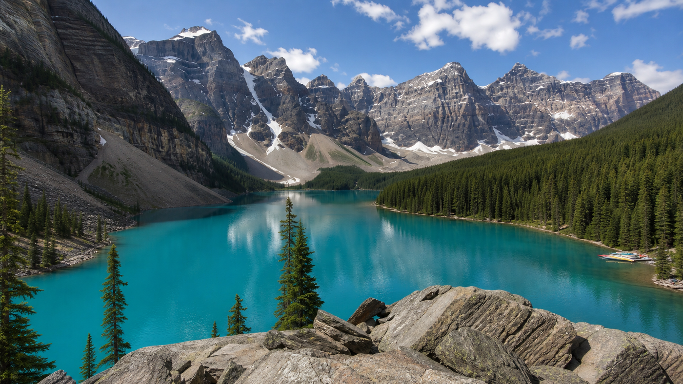
Moraine Lake from the Rockpile
Moraine Lake has been photographed so often that it might seem over-familiar before you arrive. Then you climb the Rockpile, the Valley of the Ten Peaks closes in around the water, and the lake turns that impossible blue that still manages to look slightly suspicious, as if nature has been fiddling with saturation settings. The famous viewpoint works because it has balance: shattered grey rock in the foreground, dark conifers at the shore, then that long band of glacial water and a procession of sharp peaks behind it. It feels ceremonial, almost composed. The trick is to give it time. Do not rush up, shoot once, and dash back to the shuttle queue. Walk the shoreline afterwards, listen to the loose scree under your boots, and watch how the colour shifts as the sun moves over the basin.
Access and reservations: Moraine Lake Road is closed to personal vehicles year-round. Access is limited to Parks Canada shuttles, licensed commercial operators, and registered guests of Moraine Lake Lodge, with the seasonal transport window generally running from June to mid-October, weather permitting.
Best photo spot: The Rockpile walk is the classic angle, but the lakeshore path adds quieter, lower-level views once the famous panorama is safely in your pocket. The upper Lake Louise area map also flags Moraine Lake as a high-elevation zone where trail safety and seasonal conditions matter.
Food and nearby stop: In Lake Louise village, Trailhead Cafe is a reliable stop for coffee, breakfast and something sturdier than a granola bar before or after the lake. If you are building a fuller day, pair Moraine with Lake Louise rather than sprinting between too many roadside icons.
Peyto Lake from Bow Summit
Peyto Lake is one of the great Icefields Parkway scenes because the view arrives all at once. You leave the road, walk uphill barely long enough to warm up, and suddenly the lake is spread below in a shape that looks designed for postcards and mildly dramatic gasps. On a clear day it glows with that dense glacial turquoise that photographs well and still feels better in person. The broader pleasure, though, is the setting. Bow Summit sits high enough that you do not just see a lake. You look into a whole alpine basin, with forests, ridges and weather all part of the same frame. If Moraine Lake feels theatrical, Peyto has a colder, cleaner elegance. It is the kind of place where even serial road-trippers start speaking in full sentences again only after a minute or two.
Access and difficulty: The main Peyto Lake Lookout trail is short and easy, about 0.6 km one way with modest elevation gain. A barrier-free 0.3 km trail is available from the upper parking lot.
When to go: The strongest lake colour usually shows in summer, while shoulder-season visits can mean clearer air and fewer people. Official Banff trail and closure pages are worth checking because high-elevation conditions and short-term closures do happen.
Scenic add-ons: Peyto is one of the best excuses in Canada for driving the Icefields Parkway slowly. Bow Lake, Mistaya Canyon and the Columbia Icefield all sit naturally on the same run.
Lake O’Hara and Opabin Prospect
Lake O’Hara is what happens when a famous mountain landscape is protected just enough to keep its voice low. The basin is full of jewel-blue lakes, hanging valleys, stone paths and tidy alpine drama, but the place never feels loud because access is tightly managed. From Opabin Prospect, the Lake O’Hara basin opens in layers, with water, rock ledges, conifers, pale cliffs and a sweep of high country beyond. It is not a single giant reveal like Peyto. It is more refined than that, a view that rewards the second and third glance. The real pleasure lies in the details: polished quartzite, larches edging the slopes, the hush that settles once the morning arrivals scatter onto different trails. If you like your mountain scenery with a little grace and a lot of patience, this is one of Canada’s great days out.
Access and reservations: Day-use and camping access are managed through Parks Canada shuttle reservations, with 2026 day-use shuttle spots distributed by random draw. Prime hiking season is roughly July through late September, and many higher routes can remain snow-bound until late June.
Hike note: The Opabin Plateau Circuit is a 5.9 km circuit with about 250 m of elevation gain, and it is the natural way to fold Opabin Prospect into a fuller Lake O’Hara outing (moderate).
Practical stop: Bring lunch. The one civilized indulgence here is time, not a restaurant table. If you do want a proper meal afterwards, Field is the nearest village base, while the O’Hara planning pages stress that the day itself needs to be self-sufficient.
Spirit Island on Maligne Lake
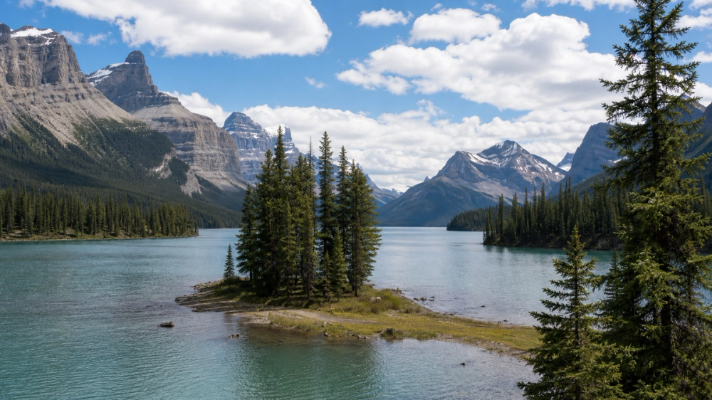
Spirit Island is one of those Canadian views that somehow survives its own fame. The island itself is small, almost modest, but that is exactly why the setting works. The dark blue-green water of Maligne Lake stretches behind it, steep slopes hold the shore, and pale mountains ring the background with a sort of solemn calm. The best part is the approach. You do not drive to a viewpoint and tumble out with half the boot of the car still open. You move toward it over water. The lake narrows, the surrounding peaks lean in, and by the time Spirit Island appears, it feels like the end of a slow introduction rather than a quick stop. Take the hint and linger. This is one for unhurried eyes.
Access: Maligne Lake lies 47 km from Jasper at the end of Maligne Road, and Parks Canada notes there are no gas stations on that road. The classic public access to Spirit Island is by boat cruise, with the 2026 cruise season listed from late May to early October, weather permitting.
Safety and planning: Parks Canada notes that Maligne Lake is cold, even in mid-summer, and exposed to high winds. If you are paddling rather than cruising, treat it with respect.
Food and nearby experience: Bear’s Paw Bakery in Jasper is the sort of place people quietly promise themselves they will revisit before leaving town. Pair Maligne Lake with nearby Maligne Canyon if you want a second, shorter dose of drama on the same day.
Wilcox Pass and the Columbia Icefield
Wilcox Pass has none of the polished charm of a lakeside boardwalk, which is very much its appeal. The trail climbs above the Icefields Parkway into open, wind-rubbed country where the Athabasca Glacier and Columbia Icefield suddenly feel close, heavy and serious. The landscape here is all appetite and erosion: pale rock, old ice, broad valleys and mountain walls that make the human scale look faintly silly. It is one of the best glacier views in Canada because you do not just stare at a white mass from a roadside sign. You move upward into its weather. On many days the view improves with passing cloud, when shadow slides over the icefield and the whole basin looks older than the road below ever intended to suggest.
Hike difficulty: Jasper lists Wilcox Pass and Wilcox Pass Ridge as hiking trails in the Columbia Icefields area, and current trail reports classify the route as difficult with frequent high-elevation condition issues early in the season. Call it difficult rather than “a brisk stroll before lunch.”
Seasonality: Snow patches and wet sections can linger well into June, and current Jasper trail conditions should be checked before setting out.
Scenic drive: The Columbia Icefield area sits on the 230 km Icefields Parkway between Lake Louise and Jasper, one of the finest drives in the country and a natural place to combine viewpoints rather than racing past them.
Upper Waterton Lake from the Prince of Wales Hill
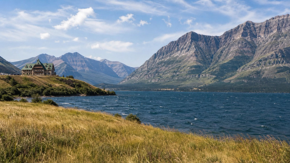
Waterton has always had a slight taste of weather about it, and that is part of the fun. The mountains rise abruptly from prairie country, the wind tends to arrive with opinions, and Upper Waterton Lake stretches south in one long blue corridor that feels elegant rather than flashy. From the bluff by the Prince of Wales Hotel, the composition is close to perfect: lake, townsite, mountain walls and that famously photogenic hotel watching over the whole thing like a grand old actor who still knows where the light is best. It is one of the finest easy-access mountain views in Canada. You barely have to work for it, which is refreshing now and then. Even devoted hikers deserve a good bluff with a dramatic breeze.
Nearby hike: If the bluff leaves you wanting more height, Bear’s Hump starts opposite the Prince of Wales access road and gives you a stronger overhead angle on the town and lake (moderate). Parks Canada lists it at 2.8 km return with 225 m of elevation gain.
Timing: Sunset is especially good here, when the lake darkens and the hotel catches the last warm light. Wind can be fierce, so pack a layer even on a mild day. Parks Canada says as much, in gentler language and with fewer complaints about hair.
Nearby stop: The Prince of Wales Hotel itself is the obvious place for tea or a drink with a view. If roads are open and you have more time, Red Rock Canyon and the paths around the townsite make a satisfying longer visit.
Panorama Ridge above Garibaldi Lake
Few hikes in British Columbia deliver such an emphatic final scene. After the forest, the switchbacks, the meadows and the long grind past Garibaldi Lake, Panorama Ridge opens and the whole alpine basin drops away in startling colour: glacial blue water, dark volcanic forms, snow and ice clinging to higher slopes, Black Tusk lifting its unmistakable silhouette into the skyline. It is a big, clean, almost absurdly photogenic view, yet it never feels cheap because the hike makes you earn it. By the time you reach the ridge, your legs know exactly what they think of the place. Fortunately your eyes usually win the argument. On a clear day this is one of those summits where people fall uncharacteristically silent for a few minutes, which in any busy mountain corridor is a compliment.
Access and passes: Panorama Ridge is reached from the Black Tusk/Garibaldi Lake, Rubble Creek, side of Garibaldi Park. BC Parks requires summer 2026 day-use vehicle passes at Rubble Creek on Fridays through Mondays and holidays from June 12 to October 12.
Hike difficulty: This is a long alpine day and belongs firmly in the difficult category. BC Parks describes the Garibaldi Lake and Black Tusk area as ranging from easy to difficult, with Panorama Ridge among the major backcountry objectives.
Food and base: Stay in Squamish or Whistler the night before if you can. For breakfast or recovery, Fox & Oak in downtown Squamish is a real coffee-and-bakehouse stop, and it is much better than starting a hard hike on a gas-station muffin.
The Stawamus Chief over Howe Sound
The Stawamus Chief is one of the country’s best trade deals. You put in a steep, sweaty climb, possibly mutter something impolite on the stairs, and a little later you are standing on warm granite above Howe Sound with the Sea-to-Sky corridor laid out below like a map for better decisions. The beauty here is in the collision of elements. You have ocean, islands, granite, forest, highway and town in one dramatic sweep, with the Coast Mountains crowding the horizon. It feels very British Columbia in the best, most unfairly photogenic sense. First Peak gives the classic hit. Second and Third Peak are quieter and broader if you still have energy to spend. Either way, this is a summit that has launched many post-hike burger cravings and no small number of overly confident weather forecasts.
Hike difficulty and safety: BC Parks is blunt here, which is appreciated. The Chief Trail is steep and difficult, winter stairs can be slippery, and rockfall is possible. Treat this one as difficult and do not save your sensible footwear for another day.
Nearby stop: Shannon Falls Park sits right beside the access and gives you an easy 350 m walking trail, useful if you want a second scenic stop without another uphill negotiation (easy).
Food stop: Squamish has good post-hike options. Fergie’s Cafe is the classic brunch answer just outside town, and Howe Sound Brewing offers a solid, real-meal finish in Squamish itself.
Berg Lake and Mount Robson
Mount Robson has presence. That may sound vague until you see it, at which point it sounds insufficient. The mountain rises above the valley with a real sense of authority, often wrapped in weather, and Berg Lake sits below with glaciers pressing toward the water in a scene that feels more northern and more severe than many celebrated Rockies classics. The beauty of the Berg Lake trail corridor lies in its slow build. Forest gives way to wider valley views, rivers and waterfalls mark the progress inward, and then the full mountain-and-glacier drama takes over. When the cloud lifts, even briefly, the whole place seems to sharpen. It is one of Canada’s great backcountry views because it never feels casual, never merely decorative. The landscape is doing actual mountain business here. You are just lucky enough to pass through.
Access and advisories: BC Parks says the Berg Lake Trail has been repaired after closures caused by extreme weather, but visitors should still check advisories before hiking any part of it.
Hike difficulty: Berg Lake is a backcountry hiking route, best treated as difficult if you are going all the way in. Overnight visitors need to plan camping or backcountry arrangements carefully.
Base and practical stop: Valemount and Jasper are the obvious service bases before and after the hike. If you are approaching from Jasper, Bear’s Paw Bakery remains a highly strategic stop for coffee and trail morale.
Tombstone Territorial Park from Goldensides
Tombstone Territorial Park looks as though the Yukon briefly decided subtlety was overrated. The ridges are dark and sharply cut, the valleys wide and quiet, and the tundra glows in late season colours that look almost too carefully arranged. Goldensides is one of the best introductions to this landscape because it gives real scale without demanding a full backcountry expedition. The hike is short enough to fit easily into a Dempster Highway day, but high enough to push the valley open around you. This is a good thing because Tombstone earns its legend from distance and texture: the loneliness of the highway, the shift from boreal forest to alpine and tundra, the feeling that the country ahead is still largely on its own terms. If you like your viewpoints with a bit of frontier in the logistics, this one has excellent manners and glorious scenery.
Hike difficulty and distance: Yukon lists Goldensides at 5 km return and 2 to 3 hours, with a moderate rating.
Services and timing: The Tombstone Interpretive Centre sits at km 71.5 on the Dempster Highway, open daily in summer with maps, interpretive programs and toilets, but no food or gas. Dawson City is where you stock up properly.
Nearby experience: Tombstone Mountain Campground and the short trails around the interpretive centre are good if you want a slower day or an evening walk after Goldensides. The Dempster itself is half the point, so do not treat this as a dash in and out.
Western Brook Pond in Gros Morne
Western Brook Pond begins with understatement. The walk to the dock crosses low terrain of bog and forest, placid enough that first-time visitors may start wondering whether the brochure has been overselling matters. Then the boat noses into the landlocked fjord, the cliffs close in, waterfalls begin to appear, and the whole landscape shifts scale with a kind of effortless swagger. The water is freshwater, the walls are immense, and the place has that old, stripped-down geology that makes your own travel plans feel quite temporary. It is one of the most beautiful scenes in Atlantic Canada, not because it shouts, but because it unfolds. On a clear day the reflections are exquisite. In mist, which is hardly unknown here, the cliffs rise out of cloud with a drama that feels almost impolite. Either mood works. Newfoundland is generous that way.
Access: Parks Canada says the approach is a 2.7 km easy gravel and boardwalk trail to the boat departure point, and boat tours typically run from mid-May to mid-October, weather permitting.
Nearby hike: The Tablelands are the obvious nearby contrast, a famously strange ultramafic landscape in the same national park. The main Tablelands route is a worthwhile second outing (moderate).
Food stop: In Rocky Harbour, Java Jack’s is a long-established, reservation-worthy stop in the heart of Gros Morne, and one of the few places where a post-boat meal can feel as memorable as the geology if you play your cards well.
Signal Hill over St. John’s Harbour
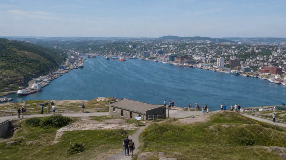
Signal Hill lands somewhere between Atlantic cliff walk, historic site and urban balcony, which is precisely why it is so good. From the top you get the entrance to St. John’s Harbour, the Narrows, the Atlantic beyond, Cabot Tower, and the colourful city climbing back along the slopes. The view is wide, but it still feels intimate because the harbour folds in on itself so neatly. Wind usually arrives early and stays late. Fog can turn the whole site into maritime theatre. On a bright day the city colours pop and the cliffs feel crisp. This range of moods is part of the pleasure. Signal Hill does not need perfect weather to work. In fact it might even prefer a little drama. Many places claim to be atmospheric. Signal Hill barely has to try.
Best walk: The North Head Trail runs from the summit parking area and is listed by Parks Canada as 1.7 km one way and difficult. If you want something shorter, the Centre to Summit trail is 500 m one way and moderate.
Food stop: Rocket Bakery downtown is the classic regroup point for coffee, pastries and a sensible pause after the wind has rearranged your plans and, quite possibly, your hair.
Nearby stop: Cape Spear is the natural companion outing, another Parks Canada site on a rough Atlantic headland and a very good place to continue the coastal mood once Signal Hill has done its job.
Skyline Trail in Cape Breton Highlands
The Skyline Trail knows exactly what it is doing. It begins quietly enough, then works its way toward a boardwalk at the edge of the headland where the Cabot Trail curls below the cliffs and the Gulf of St. Lawrence spreads outward in one long exhale. At sunset the whole scene turns syrupy and gold, and even travellers who generally resist the phrase “worth the detour” tend to give in. It is popular, yes, but popularity feels understandable here rather than annoying. The view is simply that good. Better still, the trail is accessible enough for a broad range of walkers, which means you do not need to spend half the day suffering to arrive at one of Atlantic Canada’s proper showpieces. You just need decent timing, a layer for the wind, and enough good sense not to rush off before the light gets really interesting.
Access and parking: Parks Canada requires Skyline Trail parking reservations during the 2026 peak season, with the system in place from June 26 to October 25.
Hike difficulty: Parks Canada classifies Skyline among the park’s hiking routes and rates the main outing as easy to moderate, depending on whether you do the shorter out-and-back or longer loop option.
Food stop: Chéticamp is the obvious base, and L’abri Restaurant & Bar gives you a very handy reward mechanism after the hike, with a waterfront setting and year-round operation on the Cabot Trail.
Percé Rock from the Mont-Sainte-Anne sector
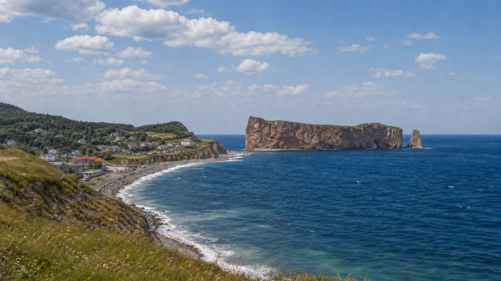
Percé Rock is impressive enough from the village shore, but the broader magic appears when you gain a little altitude and take in the whole set: the village, the gulf, Bonaventure Island, and the great limestone tooth offshore that has lured camera shutters for generations. From above, the place feels less like a single landmark and more like a complete coastal scene. Fishing-town roofs cluster beneath the hills, the sea takes on that very Gaspé blue, and the rock itself seems to sit in perfect relation to everything around it. The atmosphere is part of the draw too. Percé has enough breezy old-holiday-town charm to make an ordinary afternoon feel longer and better than planned. Which, for the record, is one of travel’s best talents.
Seasonality and access: The Île-Bonaventure-et-du-Rocher-Percé park and island trails operate seasonally, with 2026 access listed from May 31 to October 12, weather and conditions permitting. Île Bonaventure is accessible only by boat, via private operators.
Nearby hike: On Île Bonaventure, the Les Colonies trail is 6.8 km round trip and classed as intermediate, a good way to combine seabirds, sea cliffs and one of Quebec’s great island walks (moderate).
Snacks and practicalities: The park service point Le Relais des Fous serves refreshments and snacks near the gannet colony in season, while the village itself is your better bet for a proper seafood lunch before or after the boat.
L’Acropole des Draveurs in Charlevoix
L’Acropole des Draveurs is the hike people mention with a slightly suspicious smile, the one that starts as a good idea and becomes a stern negotiation with your calves before turning into one of Quebec’s most thrilling viewpoints. The trail climbs out of forest onto a series of airy summits above the Hautes-Gorges-de-la-Rivière-Malbaie. From the top, the Malbaie valley opens in waves of rounded mountains, steep rock walls and enormous forest. In autumn the colours become absurdly rich. In summer the landscape feels broad and gentle from a distance, though the climb in no way shares that temperament. The reward is worth every uphill complaint. This is Charlevoix at full scale, less postcard village and more vast northern relief, with enough sweep to make even seasoned hikers pause before rummaging for lunch.
Hike difficulty: Sépaq calls L’Acropole-des-Draveurs one of the most difficult trails in its network, with 800 m of elevation gain. It belongs firmly in the difficult category.
Seasonality and water: In 2026 the trail reopened on June 12, and the park notes it is normally accessible from the second Friday in June to Thanksgiving Monday, conditions permitting. Sépaq also recommends bringing at least 2 litres of water per person.
Nearby base: Baie-Saint-Paul and La Malbaie remain the natural overnight and meal bases before or after the hike, if only because a proper chair and a proper dinner feel very well deserved here. The park itself is reached via Route 138 through Saint-Aimé-des-Lacs.
Québec City from Terrasse Dufferin and Pierre-Dugua-De Mons Terrace
Some views work because they are grand. Québec City’s cliffside terraces work because they are grand and deeply walkable. On Terrasse Dufferin, the Château Frontenac rises immediately behind you, the St. Lawrence opens below, and the old city streets seem to funnel toward the river in a way that feels almost theatrical. Continue toward Pierre-Dugua-De Mons Terrace and the angle improves again, with the city wall, rooftops, river and château all settling into a single broad panorama. It is a place for pacing rather than rushing. Morning gives you room to breathe. Evening gives you warm stone, gold light and the odd sensation that North America has quietly borrowed a little Europe for the hour. The view is beautiful, certainly, but the genius lies in how naturally it folds into a day of stairways, cafés and aimless but respectable wandering.
Best angle: Dufferin Terrace is the classic riverfront promenade, while Pierre-Dugua-De Mons Terrace gives you the stronger panoramic angle over the château, city, river and even Île d’Orléans.
Nearby walk: The funicular connects Dufferin Terrace down to Quartier Petit-Champlain and Place Royale, which makes it very easy to turn the viewpoint into a half-day ramble without repeating the stairs unless you want to.
Food stop: Paillard is a dependable bakery-and-coffee move in Old Québec, and La Maison Smith at Place Royale is another smart pause if you want sandwiches, pastries or just an excuse to sit somewhere handsome for twenty minutes.
Lion’s Head Lookout over Georgian Bay
Lion’s Head has that pleasing habit of making people question what province they are in. The Bruce Peninsula’s limestone cliffs, cedar trees and startlingly clear blue water can look almost Mediterranean on a generous summer day, though the forest, the Escarpment and the cool air pull things back to Ontario soon enough. The lookout itself is the prize: white rock, broad sky, Georgian Bay stretching outward in calm bands of colour. It is a clean, satisfying view, all edges and water, and one of the best that Southern Ontario can deliver without resorting to an elevator. The mood is improved further by the relative simplicity of the trip. No elaborate logistics, no glacier bus, no shuffle of timed-entry slots across three apps. Just a good trail, a little planning, and the good sense to bring water.
Access and parking: Lion’s Head Provincial Park is a nature reserve with no visitor facilities. The Bruce Trail Conservancy notes that the McCurdy Drive lot is the closest parking for the lookout and that paid reservations are required from May 15 to October 15.
Hike difficulty: The lookout route is best treated as moderate, with some rough and rocky sections depending on the loop or side trails you choose. Stay on marked trails to protect the fragile cliff-edge habitat.
Nearby stop: Lion’s Head village works well for a simple lunch, while Tobermory makes a good longer detour if you want to turn the viewpoint into a fuller Bruce Peninsula day.
Top of the Giant in Sleeping Giant Provincial Park
Top of the Giant is the sort of day hike that turns into dinner-table material later. The trail is long, the footing can feel endless, and then the cliffs appear above Lake Superior and all complaints lose their audience. From the top, Superior unfurls like an inland sea, with a horizon so broad it resets your sense of scale. The rock face drops away, the Sibley Peninsula stretches around you, and the whole place feels far bigger than many travellers expect from Ontario. This is a view that delivers stature, not prettiness. Everything about it is expansive: the water, the sky, the walk in, even the silence if you catch it on a quieter weekday. It is one of the province’s best full-effort rewards, and one of the easiest ways to understand why Lake Superior tends to inspire language slightly larger than average.
Hike difficulty and timing: Ontario Parks lists Top of the Giant as a challenging 21.8 km round-trip hike from the South Kabeyun trailhead, usually taking 6 to 10 hours. It is very much difficult.
Nearby stop: If your legs would prefer a shorter encore, Thunder Bay Lookout and the Sea Lion area give you more Sleeping Giant scenery with much less labour.
Food and base: Thunder Bay is the obvious base for overnighting and a proper post-hike meal. If you want a second regional view without another epic, the Terry Fox Monument also looks out over Lake Superior very handsomely.
Niagara Falls from Queen Victoria Park
Niagara Falls is so familiar in photographs that many first-timers arrive half-convinced the real thing will feel overscripted. Then the water appears, the roar starts properly, mist blows over the promenade and the scale snaps into focus. Queen Victoria Park gives you the classic Canadian-side sweep, with the American Falls, the Horseshoe Falls and the river all held in one broad frame. The park itself helps, with lawns, gardens and walking paths softening the edges of a place that could easily become pure spectacle. Better still, you can shift your angle without fuss. Start near Table Rock for the brute closeness of the Horseshoe, then stroll northward for wider perspectives. It is touristy, yes, because millions of people are not fools. Some places really are worth the fuss. Niagara tends to be one of them.
Access and timing: Queen Victoria Park is open daily, and Niagara Parks lists it among the prime walking routes beside the falls. Early morning is still the sanest time if you want room to breathe and fewer elbows in the frame.
Nearby experience: Journey Behind the Falls begins inside Table Rock Centre and takes visitors through tunnels to lower observation areas near the base of the Horseshoe Falls.
Food stop: Queen Victoria Place Restaurant and Table Rock House Restaurant are the two practical falls-view dining moves operated by Niagara Parks, the first with broad park-and-falls panoramas, the second directly at the brink-side Table Rock complex. Reservations are a very sensible idea at busy times.
The Toronto skyline from the Islands
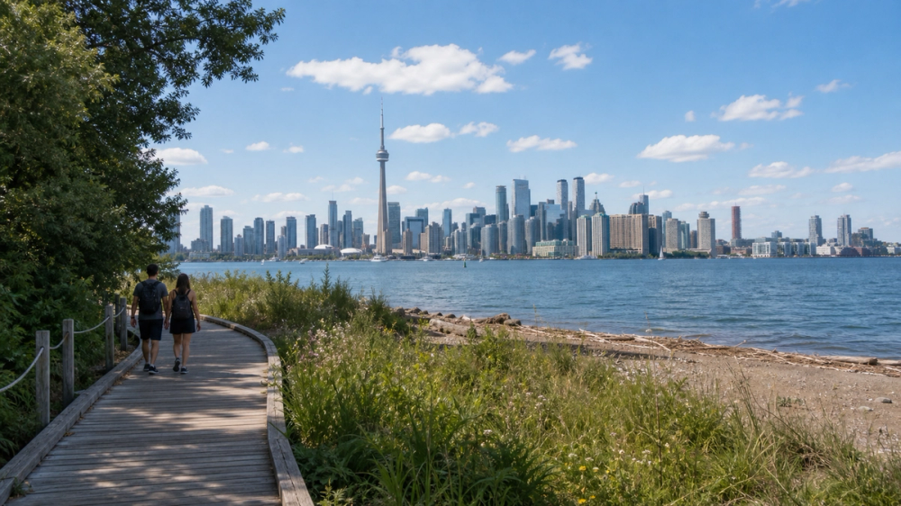
Toronto earns its beauty at a distance. From the Islands, the skyline finally has breathing room, the harbour pulls everything into balance, and the CN Tower stops looking like a landmark squeezed between obligations. The ferry crossing is part of the pleasure. Ten or fifteen minutes over water is enough to shift the city from hectic to cinematic, and once you land, the options open up nicely. Ward’s Island gives you a slower, gentler arrival. Centre Island offers easy access, more services and a classic pier view. Stay through sunset if you can. The glass towers begin to light up, the lake darkens, and the whole scene settles into that lovely city-at-arm’s-length glow that makes even locals take one more photo than planned. Toronto, it turns out, is excellent when viewed with a little distance and a mild sea breeze.
Ferry and crowd tip: City ferries to Toronto Island run year-round from the Jack Layton Ferry Terminal. The busiest route is Centre Island, and the City of Toronto explicitly suggests Ward’s Island as a calmer alternative, with about a 35-minute walk over to Centre.
Best photo spots: The Centre Island pier, Ward’s Island shoreline and parts of Olympic Island all offer open skyline views. Ward’s is especially good if you want the city framed with a little less amusement-park energy.
Make more of it: The boardwalk and beaches give you an easy add-on if you want to stretch a skyline stop into a longer summer wander (easy). Bring a picnic if you like, or plan around island cafés and downtown dinner after the return crossing.
Northern lights over Yellowknife
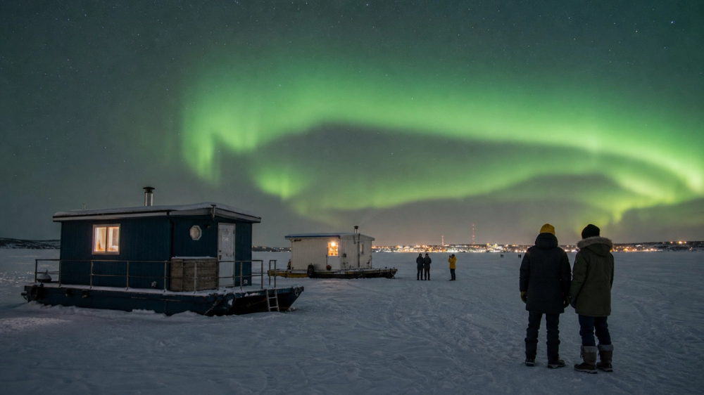
Aurora viewing has an excellent way of humbling schedules. You can line up forecasts, dress in enough layers to resemble a practical duvet, and still spend part of the evening wondering whether the sky intends to do anything at all. Then a pale arc appears, deepens to green, begins to move, and suddenly everyone around you is looking upward like they have collectively remembered something important. Yellowknife remains one of Canada’s best bases for this kind of sky-watching because it combines northern latitude, dark conditions and a well-developed aurora tourism scene. The best nights feel wonderfully disproportionate to the effort involved. You drove twenty minutes, stood outside in the cold, and ended up watching the whole sky perform. Not a bad exchange. The rest is mostly patience, warm boots and the wisdom to stay several nights rather than gambling all your hopes on one cloud chart.
Best season: Spectacular NWT describes two main aurora seasons, fall from mid-August to late September and winter from mid-November to early April, while the Canadian Space Agency notes auroras are commonly seen in northern skies and gives viewing and photography guidance.
Nearby experiences: Yellowknife is not just a wait-for-dark destination. Spectacular NWT recommends pairing aurora outings with dogsledding, snowshoeing and Indigenous-led experiences, all of which make the daylight hours pull their weight very nicely.
Food stop: In Yellowknife’s Old Town, Bullock’s Bistro is the real thing, with reservations taken directly by phone and a long-standing place in the city’s food landscape. It makes a very good pre-aurora dinner if you do not want to subsist on snack bars and optimism.
Akshayuk Pass in Auyuittuq National Park
Akshayuk Pass is not merely scenic. It is elemental. The natural corridor cuts between mountains and ice through southeastern Baffin Island, with sheer rock walls, glaciers, rivers and great austere spaces that can make even seasoned mountain travellers feel usefully small. Parks Canada calls it the park’s most popular hiking and skiing destination, but that should not be mistaken for ease. This is deep-country travel in the truest sense, a place where weather, river levels, remoteness and self-reliance matter every day. The reward is extraordinary. Rather than one single viewpoint, you get a sequence of giant northern landscapes, many with famous peaks like Thor and Asgard nearby, all carried by the strange clean silence of Arctic terrain. It is one of Canada’s most powerful travel experiences precisely because it refuses to be casual. You do not simply “pop in” to Auyuittuq. The place would laugh.
Access: Auyuittuq is reached via the communities of Pangnirtung or Qikiqtarjuaq, with access into the park by local outfitter boat or snowmobile depending on season. Parks Canada says visitors must be experienced and self-reliant, and advises contacting park staff when planning.
Route and difficulty: Parks Canada describes Akshayuk Pass as roughly 97 to 100 km long, typically taking 8 to 12 days for a full traverse, with shorter 2 to 6 day trips possible. This is emphatically difficult country.
Safety and logistics: There are 9 emergency shelters along the pass, but facilities are limited and visitors are expected to arrive with proper mapping, route planning and expedition-level preparation.
How the views compare
The table below reduces a huge country to two practical questions: when is this easiest to enjoy, and how much effort or logistics does it ask of you? Access difficulty is a planning shorthand, not a measure of beauty. A ferry ride and a ten-minute walk can still be magnificent. So can a 10-hour day hike if that is your idea of fun.
How the views compare
| View | Best window | Access difficulty | Notes |
|---|---|---|---|
| Moraine Lake, Alberta | Late June to mid-October | Moderate | Shuttle or licensed transport required because Moraine Lake Road is closed to personal vehicles. |
| Peyto Lake, Alberta | July to September | Easy | Short easy viewpoint trail; check Banff trail reports for shoulder-season conditions. |
| Lake O’Hara and Opabin Prospect, British Columbia | July to late September | Hard | Advance shuttle reservation or other limited access required; higher routes may stay snow-bound until late June. |
| Spirit Island, Alberta | Late May to early October | Moderate | Access is easiest by cruise during the operating season; road access only gets you to Maligne Lake itself. |
| Wilcox Pass, Alberta | July to September | Hard | Difficult hike in a high, exposed glacier environment; current conditions matter. |
| Upper Waterton Lake, Alberta | Late spring to early fall | Easy | Bluff view by the Prince of Wales area is straightforward; nearby Bear’s Hump adds a moderate climb. |
| Panorama Ridge, British Columbia | Late July to September | Hard | Difficult alpine hike; summer day-use pass may be required at Rubble Creek. |
| Stawamus Chief, British Columbia | Spring to fall | Hard | Steep difficult climb; extra caution in wet or winter conditions. |
| Berg Lake and Mount Robson, British Columbia | Summer to early fall | Hard | Backcountry planning essential; always check advisories. |
| Tombstone and Goldensides, Yukon | Late August to early September for colour, summer for general access | Moderate | Moderate hike, but remote-road logistics and limited services raise the planning stakes. |
| Akshayuk Pass, Nunavut | Late spring to summer | Very hard | Expedition-scale route; self-reliance and local logistics are essential. |
| Western Brook Pond, Newfoundland and Labrador | Mid-May to mid-October | Easy to moderate | Easy approach walk, then boat access for the full fjord experience. |
| Signal Hill, Newfoundland and Labrador | Year-round, with best shoulder and summer walking weather | Easy to moderate | Easy summit access by road, harder coastal trail options from the top. |
| Skyline Trail, Nova Scotia | Late spring to fall | Easy to moderate | Parking reservations are required in peak 2026 season. |
| Percé Rock, Quebec | Late spring to mid-October | Easy to moderate | Village viewpoints are easy; Bonaventure Island access is seasonal and by boat. |
| L’Acropole des Draveurs, Quebec | Mid-June to early October | Hard | One of Sépaq’s most difficult hikes. |
| Québec City terraces, Quebec | Year-round | Easy | Fully urban access, with short uphill walking between terraces. |
| Lion’s Head, Ontario | Late spring to early fall | Moderate | Nature reserve with no facilities; parking reservations apply in the main season. |
| Top of the Giant, Ontario | Summer to early fall | Hard | 21.8 km round trip, 6 to 10 hours for most hikers. |
| Niagara Falls, Ontario | Year-round | Easy | Fully developed park access and short walks between viewpoints. |
| Toronto Islands skyline, Ontario | Year-round, especially late spring to early fall | Easy | City ferry access year-round; Centre route is busiest. |
| Northern lights, Yellowknife | Mid-August to late September, and mid-November to early April | Moderate | No hiking required, but staying multiple nights is wise and aurora tours simplify logistics. |
Suggested days on the road
These are the kind of half-day and full-day outings that actually leave breathing room for weather, coffee, conversations and the unavoidable temptation to stop again because the light has turned lovely.
Suggested days on the road
| Region | Half-day plan | Full-day plan |
|---|---|---|
| Rockies | Lake Louise side, half day: take the Moraine Lake shuttle for the Rockpile and shoreline, then return to Lake Louise village for lunch at Trailhead Cafe. This is the neatest way to do one iconic lake properly without spending the day in transit lines. | Icefields Parkway day: start at Peyto Lake, continue to Bow Lake and Mistaya Canyon, then spend the afternoon around the Columbia Icefield or hiking Wilcox Pass if conditions suit and you are properly equipped. It is one of Canada’s best road days and rewards a slow pace. |
| Atlantic Canada | St. John’s half day: begin at Signal Hill for the summit view and, if energy allows, part of the North Head Trail, then head downtown for coffee and pastries at Rocket Bakery. Add Cape Spear if the weather is clear and you are still in a coastal mood. | Gros Morne full day: walk into Western Brook Pond for the boat tour, then return to Rocky Harbour for a late lunch or early dinner at Java Jack’s. If you still have daylight and good legs, use the next half day for the Tablelands rather than trying to cram both into one long blur. |
| Yellowknife and aurora country | Half day with night extension: spend the afternoon around Yellowknife’s Old Town, have dinner at Bullock’s Bistro, then join a guided aurora outing after dark. This format works particularly well on the first night, when it is useful to let somebody else handle transport and sky-chasing. | Full winter day: add a daytime dogsledding or snowshoe excursion, take a proper rest in the late afternoon, then head out again for a longer aurora session. Spectacular NWT pushes exactly this kind of combination, and for good reason: it gives the trip a shape even if the sky is moody. |
Related travel guides:
Page details
Author: Canooq Editorial
Updated: June 23, 2026
Last reviewed: June 23, 2026
Sources verified: June 23, 2026
Cite this page: Canooq.ca, 22 Unforgettable Views in Canada Worth Planning a Trip Around, https://www.canooq.ca/travel/22-unforgettable-views-canada
Canooq content is educational and may include affiliate or referral links. It is not financial, tax, legal, immigration, employment, mortgage, real estate, or healthcare advice. Verify official sources and provider terms before acting.