Banff Without Hard Hiking: Lakes, Viewpoints and Easy Walks

September 12, 2026
A place-led Banff guide to river walks, spruce forest, Vermilion Lakes, Lake Louise, Moraine Lake and easy Icefields Parkway viewpoints.
What's on this page
A low-effort Banff route through river walks, spruce forest, Vermilion Lakes, Lake Louise, Moraine Lake and the Icefields Parkway.
Banff gives you the Canadian Rockies in layers: a river cutting under spruce, glacial lakes held in bowls of stone, and roads that climb into blue distance. You can see a great deal of it without signing up for a hard hike. A good low-effort trip moves from the old mountain town to Vermilion Lakes, then spends a full day on the reserved shuttle to Lake Louise and Moraine Lake. A separate Icefields Parkway day adds Peyto Lake and Mistaya Canyon.
That leaves room for what a place should give you: a little weather, a bench, coffee, and a change in light. The walks are short, but the landscape does not feel reduced.
The easy Banff route I would choose
| Stop | Effort | Why it earns a place | Access |
|---|---|---|---|
| Bow River Trail to Bow Falls | 1.2 km one way, about 30 minutes | A river walk ending in spray, forest and mountain water | Walk from Banff or use Roam |
| Fenland Loop | 1.9 km loop, about 40 minutes | Old-growth spruce, wetland and a quiet edge of town | Walk from town or drive |
| Vermilion Lakes | Stops along a roughly 4 km lakes road | Mount Rundle, birdlife and beautiful first or last light | Drive, cycle or arrange local transport |
| Lake Louise and Moraine Lake | Easy shore and viewpoint walks, full day | The two great glacial lakes without a high trail | Reserve Parks Canada shuttle |
| Peyto Lake and Mistaya Canyon | About 30 minutes at each stop | Two concentrated Icefields Parkway landscapes | Drive or join a full-day tour |
Banff town: river water, spruce and a quiet forest loop
Banff's centre sits close to the Bow River, where the town gives way to cottonwood, spruce and the first folds of the mountains. The Bow River Trail to Bow Falls makes a fine opening walk. From Central Park, 1.2 kilometres of riverside path leads to the falls, with about 50 metres of gain and around 30 minutes of walking each way. A pedestrian bridge, dark forest and the sound of rushing water build toward the viewpoint above the falls.
Bow Falls has the kind of scale that makes a short walk feel substantial. The river narrows, the water turns white, and the Bow Valley suddenly looks less like a town backdrop and more like a living system. Winter brings ice to the path, so traction belongs in your bag when temperatures drop.
Fenland Loop gives the morning a different texture. The trail begins west of Mount Norquay Road, about 1.5 kilometres or a 20-minute walk from downtown. Its 1.9-kilometre circuit takes about 40 minutes through old-growth spruce, wetland and creek. Roots and soft ground keep the forest close to you. The elevation stays gentle.
Fenland suits the hour when Banff's main streets feel too polished for the mountains. Damp needles, creek water and the low canopy replace souvenir shops and traffic. It is a small walk with a strong sense of arrival.
Vermilion Lakes belongs to the edges of the day
Vermilion Lakes begins west of Banff and follows a chain of shallow lakes and wetlands for roughly four kilometres. Mount Rundle rises across the water, close enough to fill the view and far enough to reflect in long strips of blue. Parks Canada identifies the area as a productive early-morning birding spot.
The road earns its place through atmosphere. At first light, mist hangs above the reeds and the mountains change colour before the town is fully awake. By evening, the same water catches the last warm light on Rundle. A thermos, binoculars and ten quiet minutes beside a designated stopping area can make this feel more like a journey than an attraction.
Vermilion works best at the beginning or end of a day. Midday light flattens the scene, while dawn and dusk give the shallow lakes their depth. The route also makes a good reset between larger excursions, especially after a crowded lake or a long drive.
Lake Louise and Moraine Lake: let the lakes set the pace
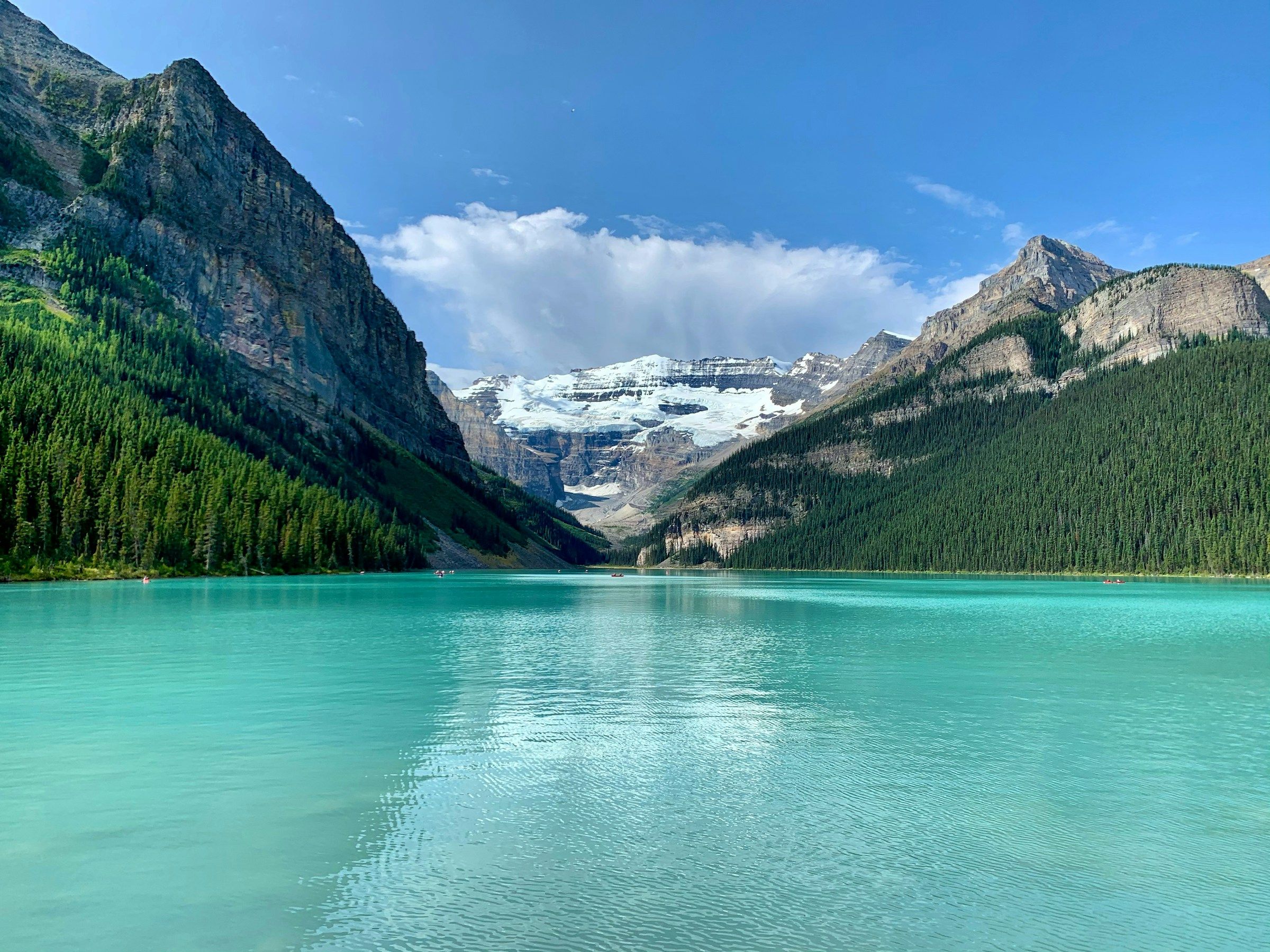
Lake Louise sits in a broad glacial bowl, its pale water opening toward Victoria Glacier and the mountains beyond. The shoreline path carries the view for you. Forest, rock, water and ice arrive in a single frame, then keep changing as clouds cross the lake. The first stretch makes a rewarding walk even when the rest of the day belongs to the scenery rather than the trail.
Parks Canada's shuttle is the calm way into the two-lake day. Moraine Lake Road is closed to personal vehicles year-round, while Lake Louise parking fills early during the busy season. The Park and Ride removes the most frustrating part of the visit and gives the day a clear beginning. A shuttle ticket can include the Lake Connector between the lakes.
For 2026, Lake Louise shuttle service runs from May 15 to October 12. Moraine Lake service runs from June 1 to October 12, weather permitting. These dates describe one season, so future visitors should confirm the current operating window before booking.
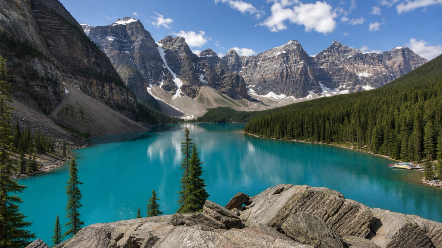
Moraine Lake feels more enclosed than Lake Louise. The Valley of the Ten Peaks rises around the water, and the short Rockpile walk opens the famous view almost at once. At the shore, the Lakeshore Trail runs 1.3 kilometres one way and takes about 45 minutes return. The route is gentle enough to leave attention for the colour of the lake, the red canoes and the changing cloud above the peaks.
The Lake Connector runs regularly during the shuttle day, but boarding still takes time. A reserved ride matters here because the road from the community is roughly 14 kilometres one way, narrow, and without a pathway. Parks Canada does not present it as a casual walk. Water, a warm layer and a little space in the schedule make the high-country day feel generous.
The 2026 adult national park entry fee is $12.25 per day. An adult Parks Canada shuttle fare is $12.75, with a $3.50 online reservation fee. Lake Louise Lakeshore parking is $42 per vehicle during the seasonal paid-parking period. The current Parks Canada access page and fees page carry the figures to check before a later trip.
Peyto Lake and Mistaya Canyon on the Icefields Parkway
The Icefields Parkway changes the scale of a Banff trip. The road leaves the town and threads through a succession of lakes, summits and river valleys. From Banff, it is a full-day outing. Bow Lake makes a natural pause beside the water, then Peyto Lake and Mistaya Canyon provide two strong rewards with little time on foot.
Nestled within Banff National Park, Peyto Lake is one of the most recognizable lakes in the Canadian Rockies. Dense forest gives way to a lookout over bright turquoise water, surrounded by rugged mountain peaks. The trail from the upper parking lot is 0.6 kilometres one way, about 30 minutes return, and the first 300 metres are barrier-free. A short approach leaves time to linger at the rail and watch the colour change with the cloud.
Mistaya Canyon brings the Parkway's geology closer. A 0.6-kilometre trail descends through forest to a narrow limestone gorge shaped by the river, with about 30 minutes of walking for the return trip. The gorge stays close and concentrated, its water forcing a path through stone. The maintained route gives the best view. Wet rocks at the edge are poor ground for improvisation.
The Parkway has limited services and parking, with weather that can change within minutes. Food, water and a warm layer matter more here than an ambitious list of stops. Travellers without a car will have a better day with an organized tour or another guided option than by trying to fit this road into a regular transit itinerary.
Johnston Canyon or the Banff Gondola
Johnston Canyon adds a longer paved walk to the easy-hiking mix. The Lower Falls sit 1.1 kilometres from the trailhead, with about 85 metres of gain and roughly an hour for the return. Railings and a paved surface make the route accessible to many visitors, while the canyon walls and running water provide a stronger sense of wilderness than the effort suggests. The trail is popular, and parking fills early. Summer Roam Route 9 can be the easier arrival.
The Bow Valley Parkway has a seasonal detail in 2026. The fall cycling restriction runs from September 1 to October 6, and the current vehicle approach to Johnston Canyon is via Castle Junction. Parks Canada's Bow Valley Parkway notice is the useful page to read before leaving.
Above Banff, the Gondola trades trail time for height. The summit boardwalk looks over the Bow Valley and the town, with a 2-kilometre option toward Sanson's Peak for anyone who wants a little more walking. The listed hours for September 8 to October 12, 2026 are 9 a.m. to 9 p.m., with the last ride up at 7:30 p.m. Advance tickets are recommended, and a same-day ticket includes the free shuttle. The view supplies the mountain drama while your legs take a day off.
Three days in Banff without a hard hike
The first day belongs to Banff itself. The Bow Falls walk follows the river out of Central Park, while Fenland Loop adds a quiet pocket of forest before lunch. Vermilion Lakes makes the best late-day finish, when Mount Rundle catches the last light.
The second day belongs to the high lakes. Lake Louise sets the scale in the morning, Moraine Lake brings the Ten Peaks closer, and the shuttle keeps the distance between them manageable. The two shore walks are enough for a full day because the colour and weather keep changing around you.
The third day reaches north. Bow Lake, Peyto Lake and Mistaya Canyon form a natural Icefields Parkway sequence for travellers with a car or organized tour. A car-free itinerary can stay in the Banff valley, use current Roam and shuttle information, or take the Gondola when the forecast opens a window over the peaks.
The small details that keep an easy trip enjoyable
Roots, gravel and wet ground still appear on easy trails. The high country can hold snow and ice outside summer, and the official Parks Canada hiking page is a better planning tool than a perfect photograph from last year. Proper shoes, water and a warm layer make short walks more comfortable.
Banff's wildlife rules apply beside the road as much as on a trail. Parks Canada recommends groups of four or more in bear country, noise that lets wildlife know you are nearby, and bear spray carried by someone who knows how to use it. Designated parking and maintained paths keep a beautiful place from becoming a dangerous one.
Banff rewards time more than distance. The best hours may be the wind moving across Lake Louise, a bird call over Vermilion Lakes, or the sudden green of Peyto below the lookout. A short walk leaves room for those moments, which is the whole point of travelling through the Rockies at ground level.
Related travel guides:
Page details
Author: Thomas Tremblay
Updated: September 11, 2026
Reviewed by: Canooq Editorial
Last reviewed: September 11, 2026
Sources verified: September 11, 2026
Cite this page: Canooq.ca, Banff Without Hard Hiking: Lakes, Viewpoints and Easy Walks, https://www.canooq.ca/travel/banff-without-hard-hiking
Canooq content is educational and may include affiliate or referral links. It is not financial, tax, legal, immigration, employment, mortgage, real estate, or healthcare advice. Verify official sources and provider terms before acting.
Enjoy Canooq? Let us keep helping you — make Canooq a preferred source on Google.