Yukon and Northwest Territories Bucket List: 9 Unmissable Things to Do
June 22, 2026
Plan a Yukon and Northwest Territories bucket-list trip with 9 memorable places, practical notes, realistic photos and ideas for building a better Canadian road trip.
What's on this page
Plan a Yukon and Northwest Territories bucket-list trip with 9 memorable places, practical notes, realistic photos and ideas for building a better Canadian road trip.
Yukon and the Northwest Territories feel like a different country stitched onto the top of the map: gold-rush streets and icefields, midnight-sun music festivals, aurora over frozen lakes, and rivers that can only be reached by floatplane. They are big, quiet, and addictive, the kind of places that make you start planning your next trip before you have even left.
Here is a Yukon and Northwest Territories bucket list, with beauty you can only experience in this part of the world.
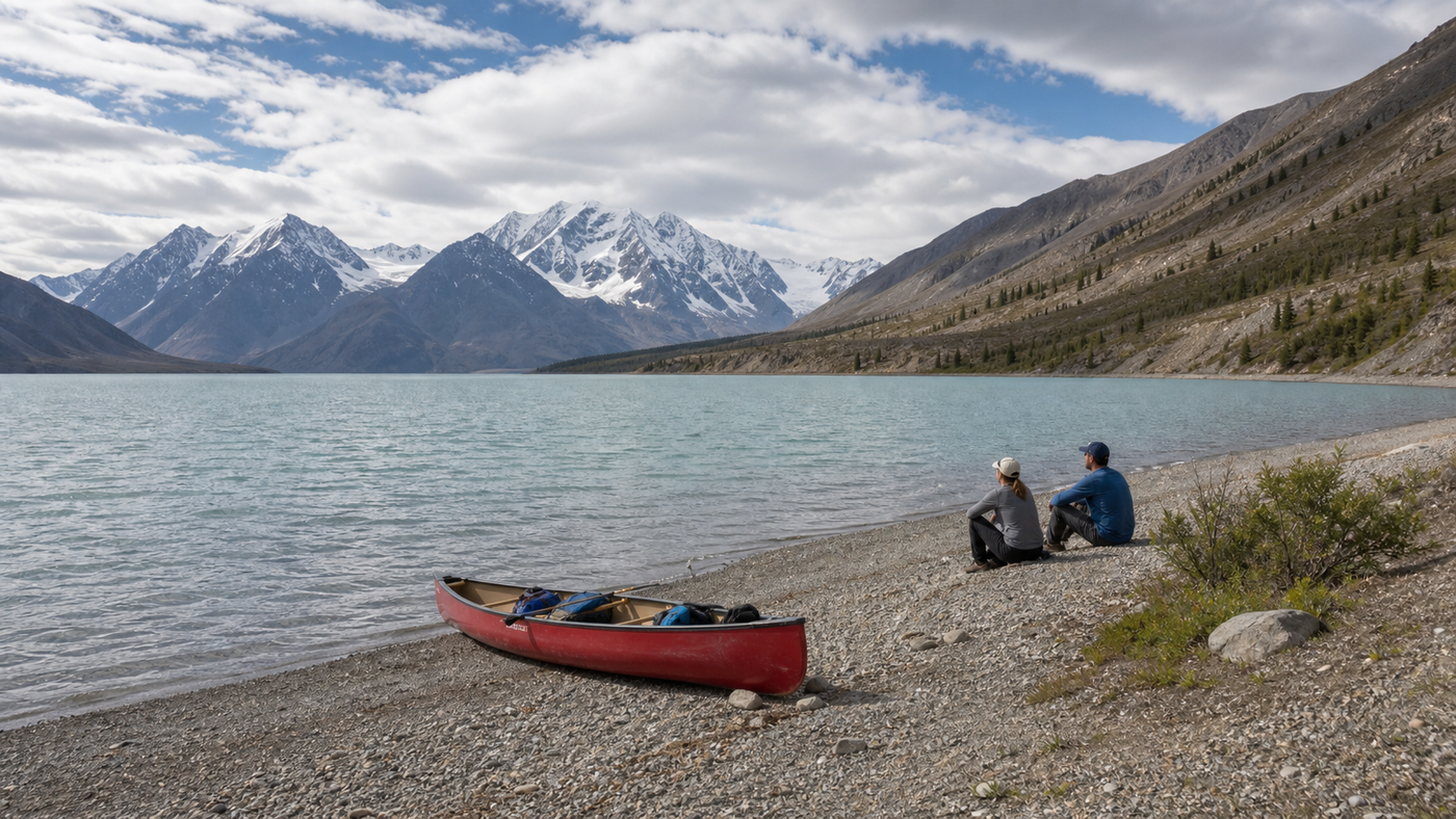
Kluane’s icefields and Kluane Lake

On the southwest edge of the Yukon, Kluane National Park and Reserve feels like the back wall of the continent: Canada’s highest peaks, some of the largest non-polar icefields on Earth, and a horizon that is mostly snow and rock. The park holds 17 of Canada’s 20 tallest mountains, including Mount Logan at 5,959 metres, and glaciers such as the Kaskawulsh pour out of the interior in thick, slow rivers of ice. From the Alaska Highway near Haines Junction, you see only a hint of what lies behind that jagged skyline.
The way to understand the scale is to take a flightseeing tour from Haines Junction or Burwash Landing, where small planes and helicopters climb over Kluane Lake and the Slims River valley into the icefields. In an hour you can skim over the six-kilometre wide Kaskawulsh Glacier, circle above serrated peaks, and, on a clear day, get a close look at Mount Logan and neighbouring giants like Lucania and Queen Mary. Some operators can even land on the ice and let you step out into an environment that feels more polar than subarctic, with nothing but snow, rock, and sky in every direction.
At ground level, the park is gentler but still dramatic. Kathleen Lake, a short drive from Haines Junction, has one of the Yukon’s prettiest front-country campgrounds and a long pebble beach where you can look straight up at the amphitheatre of King’s Throne, a steep bowl under a saw-toothed ridge. The King’s Throne trail climbs diagonally up the mountain and, even if you only go partway, gives wide views over Kathleen Lake and the surrounding valleys; strong hikers can continue to the summit for an eight-hour day that feels epic without needing ropes. A simple Kluane day might be a morning lake walk and picnic, an afternoon on a flight over the icefields, and a campfire by Kathleen Lake in the evening while the last light lingers over the peaks.
12 things to do in Riding Mountain National Park in Manitoba
Tombstone Territorial Park and the Dempster Highway
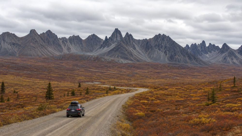
North of Dawson City, the Dempster Highway peels off the Klondike Highway and heads 700-plus kilometres of gravel toward the Arctic, crossing the Yukon–NWT border on its way to Inuvik. The first section, through Tombstone Territorial Park, is reason enough to come. Here the Ogilvie Mountains rise in jagged black teeth and U-shaped valleys filled with tundra stretch away from the road, glowing red, orange, and yellow when autumn arrives in early September. This is classic subarctic scenery that somehow manages to look both harsh and inviting at the same time.
From the Tombstone Interpretive Centre, short trails give immediate views, but it is worth putting on a pack and hiking deeper. The route to Grizzly Lake climbs steadily along a mountainside to a hanging valley where the lake sits bright and still beneath sharp peaks; backcountry campsites and cooking shelters make it a comfortable overnight even for relatively new backpackers. From there, stronger parties continue on to Divide and Talus Lakes through rolling passes where tundra plants turn every shade of rust and copper in fall. If you prefer something shorter, the Goldensides trail near the road is a half-day hike to a rounded summit with knockout views in every direction.
If you carry on, the Dempster itself becomes part of the experience: a long, mostly single track of gravel running between mountains, muskeg, and rivers, often with caribou or foxes on the verges and huge skies overhead. Many travellers spend at least five days on a Dawson–Tombstone–Inuvik–Tuktoyaktuk and back loop, with a day or two dedicated to hiking in the park on the way north or south. Fuel, food, and lodging are sparse, so you plan this one like a small expedition rather than a casual side trip.
Explore true wilderness in Tombstone Territorial Park | Travel Yukon - Yukon, Canada | Official Tourism Website for the Yukon Territory
Gold-rush Dawson City
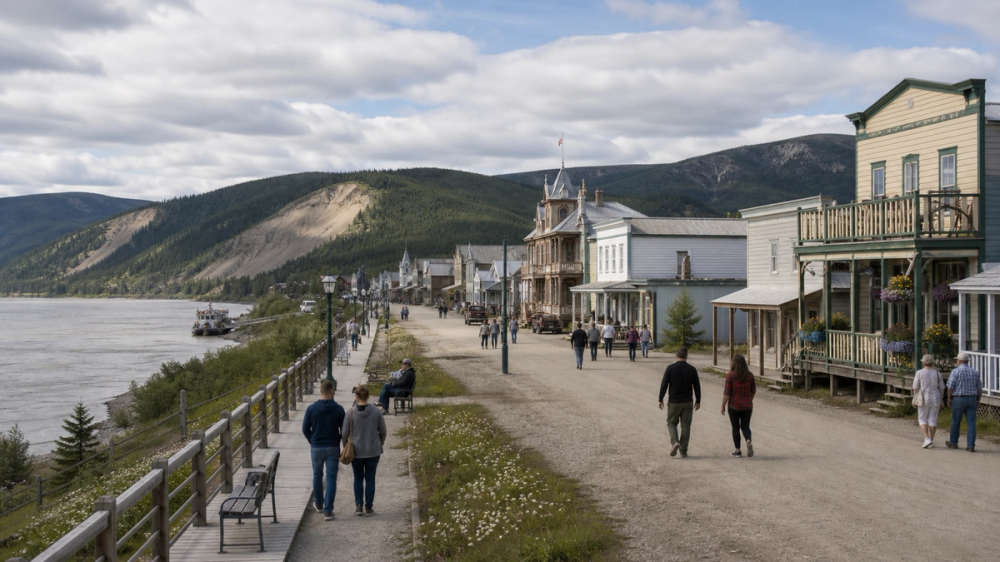
Dawson City sits on a flat of land at the junction of the Klondike and Yukon rivers, surrounded by green hills and tailings piles from long-ago dredges. In the late 1890s it exploded from a trading post into a boomtown almost overnight as tens of thousands of stampeders rushed north, and the heart of that town is now protected as the Dawson Historical Complex National Historic Site. Parks Canada looks after more than a dozen frontier buildings here, including the Palace Grand Theatre, the ornate Commissioner’s Residence, the old Post Office, and the SS Keno sternwheeler, and the whole town centre still has boardwalks, false-fronted facades, and log structures that look like props in a very real movie set.
You can spend hours simply wandering: popping into restored buildings, walking down to the river, and then climbing into the scrub behind town to the cemeteries where many early residents are buried. In the evening, people drive or hike up the Midnight Dome Road to the summit of Midnight Dome, about five miles above town at roughly 2,900 feet, for a panorama over Dawson, the Yukon River, and the Klondike valley that makes the whole gold-rush story click into place. At street level, you can join the Sourtoe Cocktail Club at the Downtown Hotel’s Sourdough Saloon, where, for a fee of around 5 dollars plus your drink, bar staff drop a mummified human toe into your whisky and recite the famous oath that ends with your lips touching the toe. It is macabre and touristy, but also very Dawson.
For a slower look at the cultural side, drop by the Dänojà Zho Cultural Centre (seasonal) on the riverbank to learn about Tr’ondëk Hwëch’in history and see that this was a First Nation meeting place long before prospectors arrived. A Dawson day could be breakfast in a local café, a walking tour of the historic complex, a lazy afternoon on the riverfront, a twilight drive up to Midnight Dome, and a late session in one of the saloons, watching the light hang in the sky well past midnight in June or July.
List of municipalities in Yukon
Whitehorse, Miles Canyon and the SS Klondike
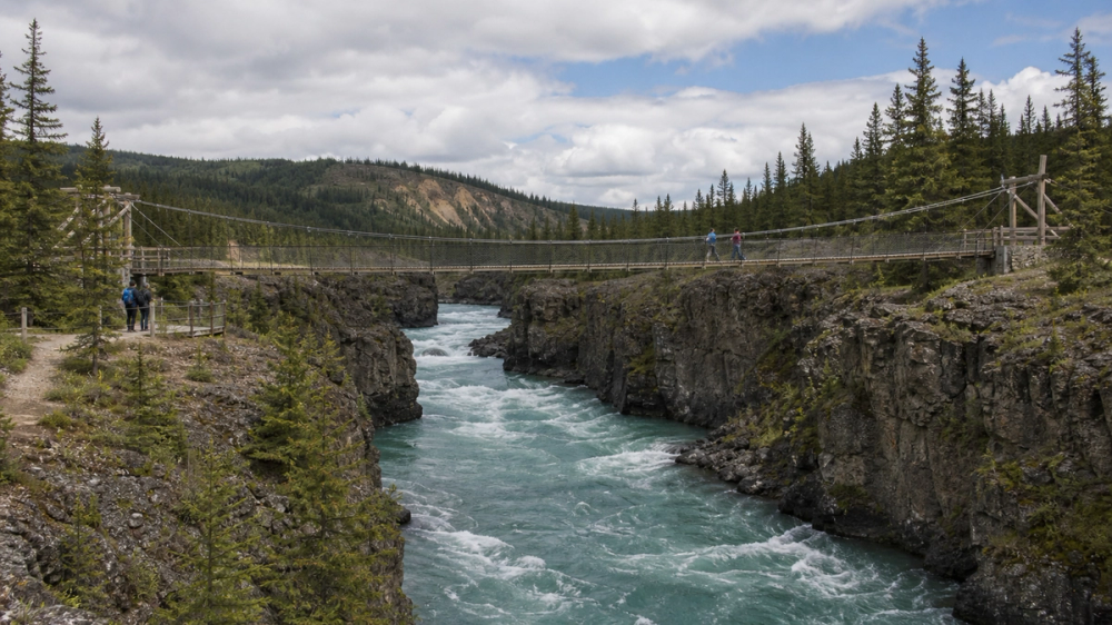
The Yukon's capital, Whitehorse, wraps around a bend in the Yukon River and feels like a place that has always been a stop on the way to somewhere else, in the best way. Stampeder boats once had to shoot Miles Canyon and the Whitehorse Rapids just upriver, so steamboats and later trains became essential links between the coast and the goldfields. Today, you can walk or bike across the suspension bridge above Miles Canyon and look straight down into green water running between lava rock walls, then follow forested trails along the riverbanks that feel surprisingly wild for something a few minutes from downtown.
Back in city limits, the restored SS Klondike, a large 1930s sternwheeler pulled up on the shore, shows how freight and passengers moved along the river before highways existed. Visiting the boat and its exhibits gives a sense of the logistics behind northern life: the stacks of crates, the cramped cabins, the amount of wood needed to keep the boilers fed on long trips. A short drive out of town brings you to natural mineral hot pools historically known as the Takhini Hot Springs, used for centuries by local First Nations and developed as a commercial bath site as early as 1907; soaking here after a day of hiking or skiing feels particularly satisfying in shoulder season when frost is in the air.
Whitehorse itself is friendly and walkable. There are coffee shops, breweries, and gear stores clustered around the main streets, and the riverfront path lets you stroll past public art and viewpoints without needing a plan. With a car, you can use the city as a base for day drives south into the Southern Lakes region or west toward Kluane, returning each night to a real bed, good food, and, in winter, the chance of aurora floating over the river.
The Forks: A Meeting Place Transformed – Winnipeg Architecture Foundation
Carcross Desert and Emerald Lake
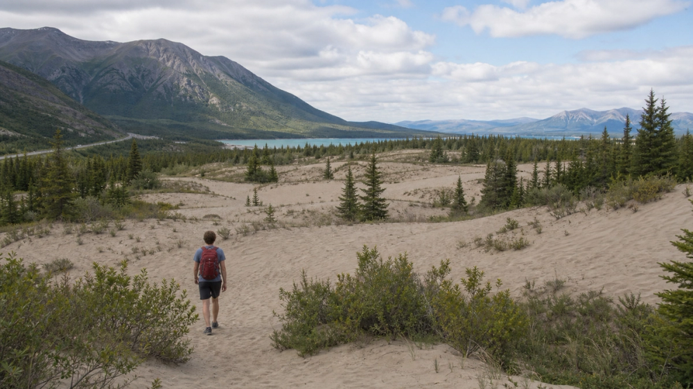
About an hour south of Whitehorse on the South Klondike Highway, the small community of Carcross sits between lakes and low mountains on the traditional territory of the Carcross/Tagish First Nation. Just outside town lies one of the Yukon’s strangest sights: the Carcross Desert, a patch of sand dunes covering roughly 642 acres that many people call the world’s smallest desert. The dunes were created when an ancient glacial lake drained and left behind thick layers of sand and silt; the Watson River still cuts through these deposits and feeds more sediment into Bennett Lake, helping to sustain the sandy landscape. You can climb the small hills, run down the slopes, and look out over sand framed by spruce forest and distant peaks, a very odd combination.
A few minutes further north along the highway, roadside pullouts give postcard views of Emerald Lake, known to local First Nations as Rainbow Lake. The water glows in bands of turquoise and jade because light reflects off a bottom layer of pale marl, a clay rich in calcium that settled when glaciers melted and lakes filled this valley about 14,000 years ago. On calm days the colours look unreal, and many travellers from Skagway or Whitehorse end up pulling over longer than they planned, just sitting on the guardrail and staring.
Carcross itself is worth more than a quick bathroom stop. There is a compact Carcross Commons area with small shops and cafés, First Nations art, and access to trails and the lakeshore, and you can easily piece together a day that runs: morning at Emerald Lake, midday exploring the desert, lunch in town, and an afternoon drive or bike ride along the lakes. If you are continuing to Skagway, this stretch acts as a scenic warm-up; if you are looping back to Whitehorse, it becomes a satisfying out-and-back that feels much bigger than its distance on the map.
Yellowknife, aurora and festivals on Great Slave Lake
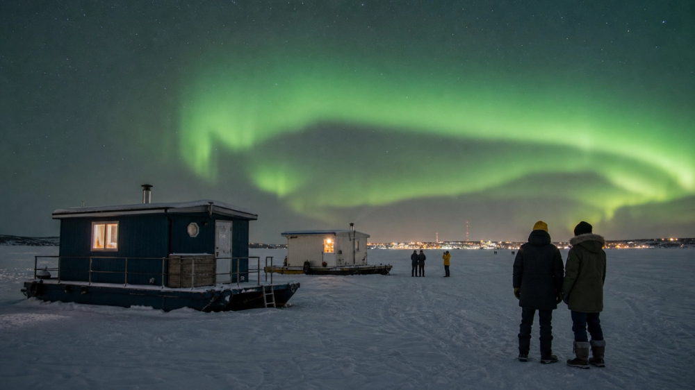
Yellowknife, on the north shore of Great Slave Lake, is the Northwest Territories’ capital and one of the world’s most reliable places to see the northern lights. The city sits directly under the auroral oval, and local and tourism sources consistently point to mid-November to early April as prime viewing season, when long, cold nights and often clear skies give you high odds of a show if you stay at least three nights. On good nights, green and sometimes pink curtains ripple from horizon to horizon, reflected in the snow or the ice of Yellowknife Bay.
You can watch from lakeshore pullouts or hilltops on your own, but many visitors join aurora camps and tours run by outfits such as B. Dene Adventures, an Indigenous-owned operator with a camp on the shore of Great Slave Lake. These camps offer warm shelters, cultural interpretation, hot drinks, and good sightlines away from city lights, turning aurora chasing into a relaxed, social evening rather than a long, cold wait by the road. In daytime, winter trips might include snowmobile tours on the frozen lake, visits to ice roads and houseboat communities, and short hikes or fat-bike rides in the rocky outcrops around town.
Yellowknife also knows how to throw a party. In July, the Folk on the Rocks music festival takes over the sandy shore of Long Lake a few kilometres from town, with three days of concerts under the midnight sun. The 46th edition in 2026 runs from July 17 to 19, bringing Canadian and international acts to a site where you can listen barefoot in the sand with people dancing in hoodies and sunglasses at midnight. In March, Snowkings’ Winter Festival carves a full snow and ice castle onto the frozen bay, complete with tunnels, slides, performance spaces, and whimsical architecture; the 2026 festival runs March 1 to 28, with daytime family hours and evening concerts inside the castle walls. Time your visit to catch at least one of these events and Yellowknife feels like a northern capital in every sense of the term.
Yellowknife - Wikipedia
Nahanni and Virginia Falls
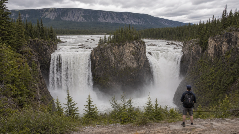
For many people, Nahanni National Park Reserve is the ultimate northern dream: deep river canyons, hot springs steaming in winter air, and a waterfall twice the height of Niagara in a valley that can only be reached from the sky. The park protects most of the South Nahanni River system in the Mackenzie Mountains of the Northwest Territories, including Náįlįcho (Virginia Falls), where the river drops about 90 metres around a central rock pillar called Mason’s Rock. From viewing platforms you feel the spray and hear the roar ricocheting off the cliffs, while spruce forest and bare ridges rise beyond the gorge.
South Nahanni River
There are no roads into Nahanni. Visitors typically reach the park by chartered floatplane, most commonly from Łįįdlı̨ı̨ Kų́ę́ (Fort Simpson), though flights also come in from Yellowknife, Muncho Lake in northern British Columbia, and Watson Lake in the Yukon. A standard day trip involves a two-hour flight from Fort Simpson into Virginia Falls, several hours on the ground walking boardwalks and trails to the viewpoints and along the canyon rim, and then a return flight that traces part of the river and surrounding ranges. More committed travellers join multi-day canoe or rafting trips that start at lakes such as Rabbitkettle or Glacier Lake and run the Nahanni’s famous canyons, camping on gravel bars under big northern skies.
Permits and registrations are required for aircraft landings and backcountry trips, and the season is short, typically from late June through early September when the river is ice-free and daylight is long. A Nahanni visit is not cheap or casual, but standing at the edge of Virginia Falls with no road, hotel, or gift shop in sight feels like stepping into one of those classic Canadian wilderness posters made real.
Chasing northern lights in Yukon and the Northwest Territories
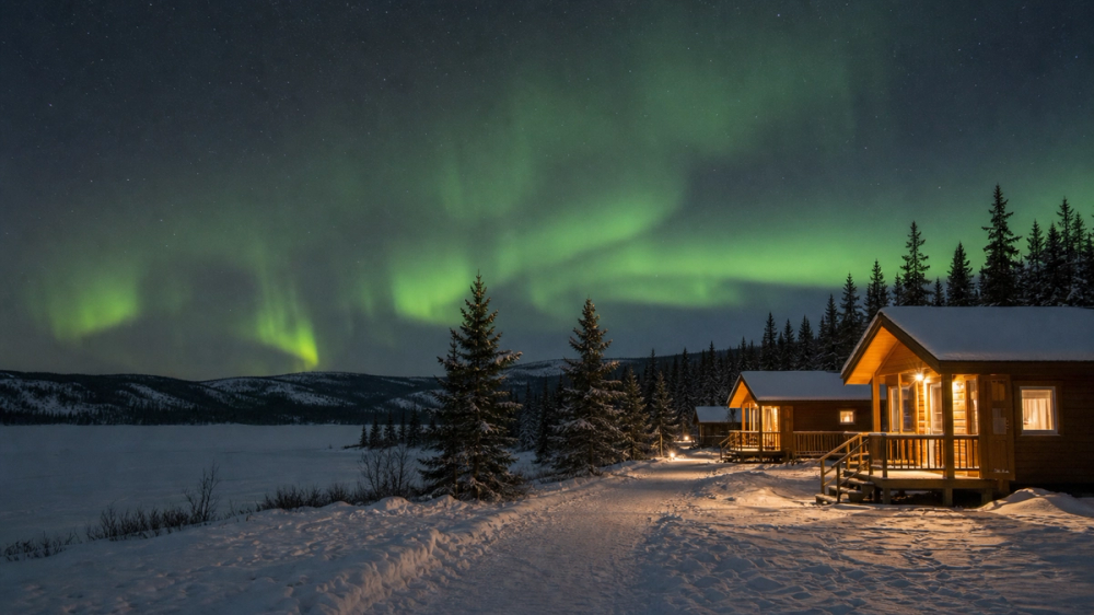
Both the Yukon and the Northwest Territories sit under the auroral oval, so the northern lights are not a side-show here, they are a full-blown reason to go north in their own right. In the Yukon, the official tourism board says the aurora is visible from mid-August to mid-April, with two main seasons: autumn (mid-August to mid-October) and winter (mid-October to early April), and a “magic window” between 10 pm and 3 am when displays most often peak. Around Whitehorse, forecast sites and local operators point to September–March as the sweet spot, with September and October offering a best-of-both worlds mix of long nights and relatively mild temperatures, and mid-winter bringing the clearest skies if you can handle the cold.
The nice thing is that you don’t always have to go far. Within 15–45 minutes of Whitehorse, locals head to places like Fish Lake, Schwatka Lake, Chadburn Lake, Grey Mountain, Lake Laberge, and the Takhini hot springs area, all mentioned in recent Yukon aurora guides for their dark skies and big horizons. On a good night you might watch ribbons of green and purple roll over the mountains and double in the lake reflections, or sit in hot mineral pools at Eclipse Nordic Hot Springs and Takhini while the sky flickers above you. If you prefer a more structured experience, operators such as Northern Tales and other Whitehorse-based outfitters run nightly tours that pick you up at your hotel, drive you to heated cabins or wall-tents outside the city, and feed you snacks and hot drinks while you wait for the show. Dawson City and the Kluane region also get excellent aurora, with Midnight Dome above Dawson and Kathleen Lake near Haines Junction singled out as favourite local viewing spots with wide, unobstructed skies.
In the Northwest Territories, Yellowknife is one of the most reliable aurora destinations on the planet: the city sits almost directly under the auroral oval, and local and travel sources note that you can see lights here up to 200–240 nights a year, especially between November and March when nights are longest. Guides stress the same late-night window, roughly 10 pm to 3 am, and recommend spending at least three nights in town to give yourself a good chance at clear skies. You can watch from pullouts on the Dettah Ice Road or shorelines around Great Slave Lake, but many visitors book Indigenous-owned camps such as B. Dene Adventures, where heated teepees or cabins, storytelling, and simple hot meals turn aurora hunting into a memorable cultural evening rather than just a photography mission. On good nights you stand on the snow or lake ice and the whole sky seems to move: arcs brightening, curtains folding over themselves, and, if you are lucky, fast “coronas” directly overhead that make you feel like you are standing inside the phenomenon rather than under it.
Inuvik, Tuktoyaktuk and the Arctic Ocean drive

For a long time the gravel Dempster Highway ended at Inuvik, a town on the Mackenzie Delta that marked the end of the road. In 2017, the opening of the Inuvik–Tuktoyaktuk Highway (Highway 10) extended all-season road access another about 87 miles (140 kilometres) to the coastal community of Tuktoyaktuk on the shore of the Beaufort Sea, creating Canada’s first public road to the Arctic Ocean. Now, drivers can leave Dawson City or Whitehorse, head up the Klondike and Dempster, cross into the Northwest Territories, and end their trip by literally walking into Arctic water.
Travel writers who have done the full route from Dawson to Tuktoyaktuk and back talk about planning at least five days, with around 33 hours of driving for the Dawson–Tuk–Dawson leg alone. The road is mostly gravel, often muddy, and rolls over tundra, river crossings, and low mountains, so you drive slowly and stay alert for changing conditions. From Inuvik, the Inuvik–Tuktoyaktuk Highway passes lakes, pingos, and open tundra before reaching Tuktoyaktuk, where you can drive to the end of Beaufort Drive, look out over the Beaufort Sea, and join the small tradition of dipping your feet or hands in the Arctic Ocean. Local operators also run boat tours to see pingos (ice-cored hills) and visit nearby communities.
Inuvik is a sensible base for the last leg. It has fuel, groceries, accommodation, and local culture to explore, including the Our Lady of Victory "Igloo Church" and community events, so many travellers leave trailers there and do Tuktoyaktuk as a long day trip, enjoying the drive without the weight of their full rigs. This whole journey is more pilgrimage than road trip, the sort of thing that people who love maps and horizons tell stories about for years afterward.
3. Yellowknife, Northwest
If you stitch these places together, you get a northern loop of midnight-sun hikes, gravel highways, floatplane landings, and late-night aurora walks along frozen lakes that will spoil you for more ordinary trips further south.
Related travel guides:
Page details
Author: Canooq Editorial
Updated: June 22, 2026
Last reviewed: June 22, 2026
Sources verified: June 22, 2026
Cite this page: Canooq.ca, Yukon and Northwest Territories Bucket List: 9 Unmissable Things to Do, https://www.canooq.ca/travel/yukon-northwest-territories-bucket-list
Canooq content is educational and may include affiliate or referral links. It is not financial, tax, legal, immigration, employment, mortgage, real estate, or healthcare advice. Verify official sources and provider terms before acting.