The most beautiful places in Canada to see once

September 13, 2026
From Moraine Lake and Pacific beaches to Labrador fjords and Arctic-scale wilderness, these are Canada's most beautiful places worth seeing once.
What's on this page
Canada is full of places that are beautiful in the ordinary sense: good beaches, mountain lakes, forest trails and coastlines you would happily revisit every summer.
Canada is full of places that are beautiful in the ordinary sense: good beaches, mountain lakes, forest trails and coastlines you would happily revisit every summer.
Then there are places that stop you for a moment.
They are not always the easiest to reach, and some are so popular that seeing them requires more planning than their photographs suggest. Others sit so far from a major road that reaching them becomes the trip. What they have in common is scale, distinctiveness or a sense of place strong enough that the journey feels justified once you arrive.
This list is deliberately broad. The Rockies are represented, but they do not get to occupy half of Canada simply because turquoise lakes photograph well. There are Pacific beaches, Atlantic cliffs, badlands, fjords, northern icefields and one waterfall so famous that it is tempting to dismiss it until you are standing beside it.
You do not need to see all of them.
But if you are building a lifetime list of places in Canada worth making a real trip for, these are the ones I would start with.
| Place | Province or territory | Best time | What makes it special |
|---|---|---|---|
| Moraine Lake | Alberta | July to September | Turquoise water beneath the Valley of the Ten Peaks |
| Pacific Rim National Park Reserve | British Columbia | May to October | Rainforest opening onto huge Pacific beaches |
| Gwaii Haanas | British Columbia | June to September | Remote islands, Haida culture and wild coastline |
| Kluane National Park and Reserve | Yukon | June to September | Canada's highest mountains and immense icefields |
| Nahanni National Park Reserve | Northwest Territories | June to August | Náįlįcho, canyons and roadless northern wilderness |
| Torngat Mountains National Park | Newfoundland and Labrador | Mid-July to late August | Arctic-scale fjords in an Inuit homeland |
| Western Brook Pond | Newfoundland and Labrador | June to September | Sheer cliffs surrounding a landlocked glacial lake |
| Percé and Bonaventure Island | Quebec | June to September | Sea stacks, cliffs and enormous seabird colonies |
| Cape Breton Highlands | Nova Scotia | June to October | Mountains dropping directly toward the sea |
| Prince Edward Island's north shore | Prince Edward Island | July to September | Red cliffs, dunes and long beaches |
| Hopewell Rocks | New Brunswick | May to October | One landscape transformed by the Bay of Fundy tides |
| Niagara Falls | Ontario | May to October | A familiar place that is still overwhelming in person |
Moraine Lake, Alberta
Moraine Lake may be one of the most photographed places in Canada, but the photographs have not ruined it.
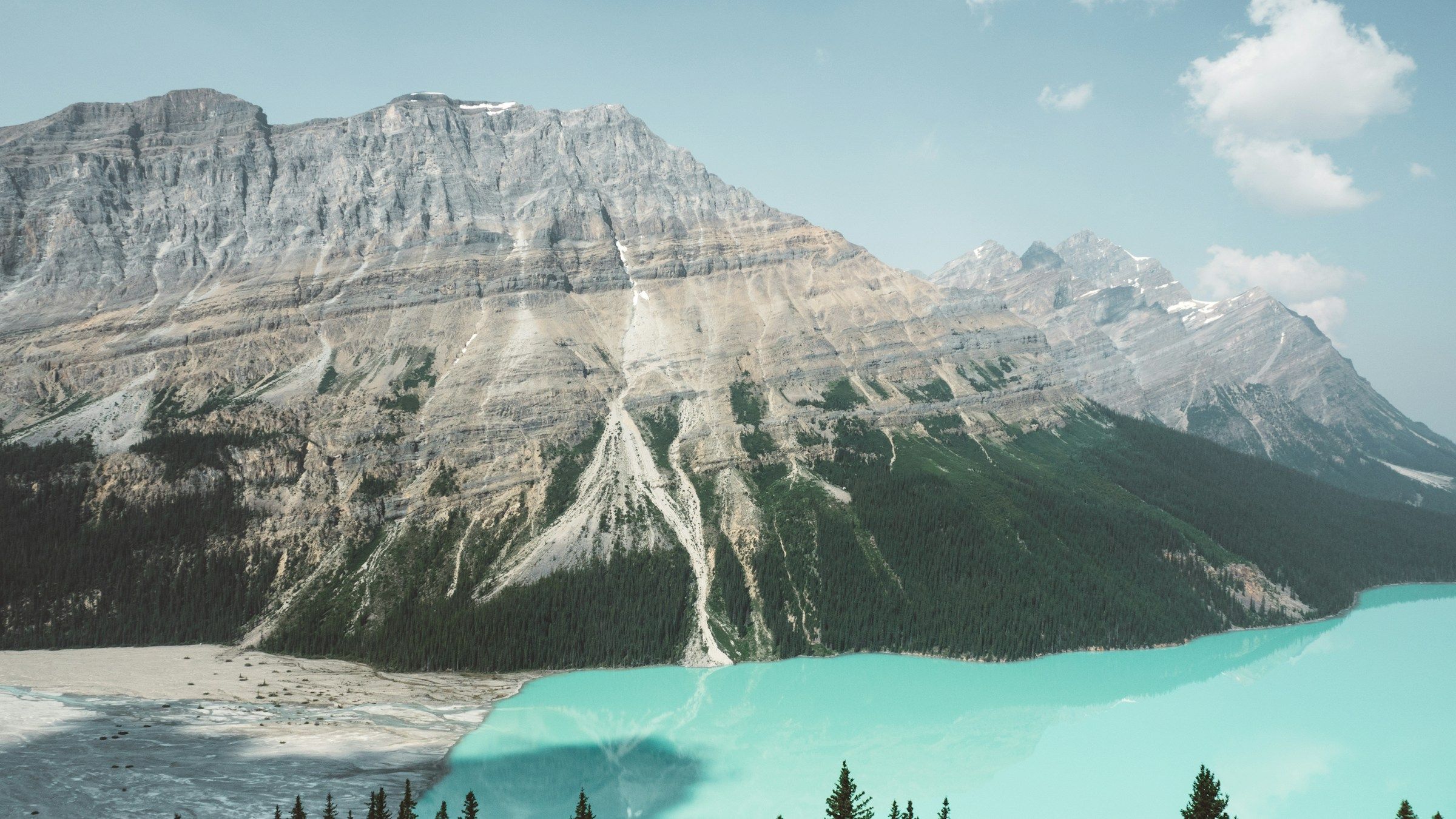
The lake sits beneath the Valley of the Ten Peaks in Banff National Park, with steep mountains rising directly behind water that turns an almost implausible blue during summer. The colour comes from fine glacial sediment suspended in the water, but understanding the chemistry does very little to make it look less artificial.
The classic view is from the Rockpile, a short trail beside the lake that climbs just high enough to reveal the full valley. It takes very little effort for a view that has become one of the visual shorthand images for the Canadian Rockies.
The difficulty in 2026 is not the walk. It is getting there.
Moraine Lake Road is closed to personal vehicles year-round. During the main visitor season, access is by Parks Canada shuttle, Roam public transit or licensed commercial transportation. Parks Canada shuttle reservations are required, and the main 2026 inventory was released in April with additional seats released two days before departure.
That planning requirement is worth taking seriously. Do not arrive in Lake Louise hoping to somehow drive up the road after breakfast.
Once you are there, give the lake more than the standard Rockpile photograph. Walk the shoreline, stay for a while after the first shuttle crowds shift and, if you are a stronger hiker, use Moraine Lake as the starting point for a longer trail into the surrounding valley.
When to go
July through September gives you the best chance of fully thawed water and open hiking trails. June can still feel early at elevation, while the access road closes seasonally as winter returns.
Long Beach and Pacific Rim National Park Reserve, British Columbia
The west coast of Vancouver Island is beautiful in a completely different way.
At Pacific Rim National Park Reserve, dense temperate rainforest runs almost to the edge of the Pacific. The Long Beach Unit stretches between Tofino and Ucluelet, where kilometres of sand face open ocean and the horizon feels much larger than it does from most Canadian beaches.
Long Beach itself is the obvious introduction.
On a clear summer afternoon, it can look almost gentle, with surfers in the water and families spread across the sand. In autumn or winter, wind and rain transform the same coastline into something much more dramatic.
Both versions are worth seeing.
The best trip gives the coast several days rather than treating Long Beach as a roadside stop between Tofino restaurants. Walk the beach early, explore the rainforest, continue toward Ucluelet and spend part of another day on the Wild Pacific Trail.
Parks Canada requires a valid national park entry pass when you stop in the Long Beach Unit. The park is accessible year-round, although visitor-centre and campground operations vary seasonally.
When to go
For the easiest weather, June through September. For storm watching and a quieter coast, late autumn and winter are arguably more atmospheric.
Gwaii Haanas, British Columbia
Some beautiful places impress you because they are large.
Gwaii Haanas is more powerful because it feels layered.
The national park reserve, marine conservation area reserve and Haida Heritage Site occupy the southern part of Haida Gwaii, where forested islands rise from narrow channels and the Pacific coastline alternates between sheltered coves and exposed sea.
There are no roads into Gwaii Haanas.
Visitors arrive by boat or seaplane, either with licensed tour operators or as experienced independent travellers. Self-guided visitors need a reservation, visitor-use fee and mandatory orientation before entering, and there is no cell service once you are inside.
That remoteness protects the experience, but the scenery is only part of the reason to come.
Gwaii Haanas is also a living Haida cultural landscape. Haida Watchmen welcome visitors at important village sites, including places where monumental poles, house remains and archaeological evidence connect the landscape to generations of Haida history.
This is not somewhere I would reduce to "Canada's hidden tropical-looking islands" or any other social-media comparison. The point is precisely that it does not need to resemble somewhere else.
If you have the time and budget, a multi-day guided trip by boat or kayak is the way to understand the place. A quick flight in and out may show you the scenery, but it does not give the islands enough time to make sense.
When to go
The practical visitor season is summer into early fall, when marine travel is most manageable and guided trips are operating.
Kluane National Park and Reserve, Yukon
Kluane is where Canada's mountain scale becomes difficult to understand from the road.
The park protects part of a vast mountain-and-icefield system in southwestern Yukon, including Mount Logan, Canada's highest mountain at 5,959 metres. The interior contains enormous glaciers and peaks that remain invisible from most roadside viewpoints.
You can still have an excellent trip without flying.
Haines Junction, around 160 kilometres west of Whitehorse, makes a practical base. From there, roads skirt the park's eastern side and give access to Kathleen Lake, trailheads and broad views toward the mountains.
But if Kluane is one of the main reasons you came to Yukon, seriously consider a flightseeing tour.
Parks Canada describes the park's interior as generally accessible only by flightseeing or serious mountaineering and ski-touring expeditions. From the air, glaciers that look like white lines between mountains become huge rivers of ice, and the scale of the Icefield Ranges becomes obvious in a way the highway cannot reproduce.
That is one of the rare occasions where an expensive tourism activity changes your understanding of a place rather than simply giving you a nicer angle for photographs.
When to go
June through September for the simplest combination of road access, hiking and flightseeing.
Náįlįcho and Nahanni National Park Reserve, Northwest Territories
Nahanni is the first place on this list where getting there genuinely becomes part of the adventure.
There are no public roads into Nahanni National Park Reserve. Most visitors arrive by chartered floatplane from communities such as Fort Simpson, and many continue through the park on multi-day river trips.
The most famous feature is Náįlįcho, formerly known as Virginia Falls.
The South Nahanni River drops in a broad, powerful curtain through remote northern wilderness before continuing into a series of deep canyons. The waterfall is almost twice the height of Niagara Falls, but the comparison is not especially useful because everything around it is different.
There is no city, casino skyline or huge parking area nearby.
There is river, rock, forest and a small air-accessed visitor area.
Charter aircraft can land at designated sites including Náįlįcho, and day flightseeing trips are possible, which means you do not have to commit to a two-week paddling expedition to see Nahanni. Still, this is a place where spending more time changes everything.
A river journey through the canyons is one of Canada's great wilderness trips.
When to go
For most visitors, summer, particularly June through August. Weather and river conditions are fundamental to travel plans.
Torngat Mountains National Park, Newfoundland and Labrador
The Torngats look like the sort of place that should be in Greenland.
At the northern edge of Labrador, huge glacier-carved fjords cut between jagged mountains, tundra spreads through broad valleys and the Labrador Sea sits beside some of the oldest rocks on Earth.
The park covers roughly 9,700 square kilometres and has no public road network.
It is also an Inuit homeland, and that cultural context is inseparable from the landscape. Inuit have travelled, hunted and lived through these valleys for centuries, and many visitors now experience the region with Inuit guides through Torngat Mountains Base Camp and Research Station.
For 2026, Parks Canada lists the visitor season from mid-July to late August, while the Base Camp is operating in July and August.
Reaching it is expensive.
Current Base Camp packages include air travel from Happy Valley-Goose Bay toward Saglek, transfers into camp, tent-style accommodation, meals and guided excursions. This is a major expedition rather than an ordinary national-park holiday.
That difficulty is exactly why the Torngats belong on a lifetime list.
There are few places in Canada where scenery this dramatic remains this removed from normal tourism infrastructure.
When to go
The practical window is narrow: mid-July through late August.
Western Brook Pond, Newfoundland and Labrador
Gros Morne National Park is full of beautiful landscapes, but Western Brook Pond is the one that does not quite look like Newfoundland.
The long freshwater lake sits between cliffs carved by glaciers, with waterfalls descending from the plateau and mountains rising almost vertically from the water.
The name "pond" is pure Newfoundland understatement.
Reaching the water requires a three-kilometre walk each way from the parking area. The trail is broad, mostly flat and accessible enough that the journey feels much easier than the landscape at the end suggests.
From the dock, a seasonal boat tour runs into the lake beneath the cliffs.
That boat is the easiest way to grasp the scale.
Photographs taken from high above Western Brook Pond are even more dramatic, but those elevated viewpoints require much more serious guided hiking and are not the standard visitor experience.
For most people, the shoreline walk and boat tour are enough.
Build at least three days around Gros Morne rather than driving in exclusively for Western Brook Pond. The Tablelands, Bonne Bay communities and coastal landscapes make the national park one of the few places on this list that could justify an entire vacation by itself.
When to go
June through September for the easiest combination of boat operations, hiking and weather.
Percé Rock and Bonaventure Island, Quebec
The Gaspé Peninsula spends hours building toward Percé.
You follow the St. Lawrence east, then the Gulf, passing small towns and cliffs before Percé Rock finally appears offshore. It is enormous enough that photographs tend to understate rather than exaggerate it.
The limestone formation stretches more than 400 metres through the water and is pierced by a vast natural arch.
But the better view is not necessarily from town.
Take a boat out toward Bonaventure Island, where the rock becomes part of a much larger coastal landscape. The island is also home to an extraordinary colony of northern gannets, and walking toward the nesting areas can place you beside tens of thousands of birds spread across the cliffs.
The combination is what makes Percé one of eastern Canada's great scenic trips: the rock would be worth seeing by itself, but the island, seabirds, cliffs and long Gaspé road make the destination much richer than one landmark.
Do not visit as a rushed turnaround from Quebec City.
Spend at least two nights in Percé and give the wider Gaspé Peninsula enough time to justify the long drive.
When to go
The main season runs from late spring into early autumn, with June through September the easiest period for boat trips and island access.
Cape Breton Highlands, Nova Scotia
Cape Breton is one of Canada's rare places where the road does much of the sightseeing for you.
The Cabot Trail wraps around the northern part of Cape Breton Island, passing through Cape Breton Highlands National Park as forested mountains rise directly from the Gulf of St. Lawrence and Atlantic.
You can drive the loop in a day.
You should not.
Spend two or three nights around Ingonish, Chéticamp or both, and let the road become a series of half-day outings rather than one long driving project.
The classic short hike is the Skyline Trail, which ends on a headland above the Gulf with the Cabot Trail curling around the mountainside below.
For 2026, Parks Canada requires parking reservations at the Skyline Trail during the busiest part of the season, so check the current rules before building a day around the trailhead.
Even if you skip the hike, Cape Breton remains one of Canada's most beautiful road trips. The best moments can be as simple as pulling into a legitimate viewpoint and realizing the road has disappeared around another mountain.
When to go
June through October. Late September and early October bring famous fall colour, along with more visitors chasing the same thing.
Prince Edward Island's north shore
Prince Edward Island is not dramatic in the way Kluane or the Torngats are dramatic.
That is part of its beauty.
The north shore combines red sandstone cliffs, pale beaches, dunes, farmland and small roads that seem to arrive at the sea every few minutes. The landscape is low and gentle, which makes the colour contrasts stronger rather than weaker.
The best section for a first trip is the coast protected by Prince Edward Island National Park, particularly around Brackley Beach, Dalvay and the Cavendish-North Rustico area.
Walk the beaches, cycle part of the Gulf Shore Way and stay late enough to see the cliffs warm up toward sunset.
Then explore outside the park.
PEI works best when the coastline is combined with farms, small harbours and seafood rather than treated as a beach resort alone.
This is also the place on the list where slowing down matters most. You can technically cover large parts of the island quickly because the driving distances are short, but the road trip becomes better once you stop using that as an excuse to cross the province three times a day.
When to go
July through September for warm-weather beach days. September is quieter and particularly good if swimming is not essential.
Hopewell Rocks, New Brunswick
The Hopewell Rocks are beautiful because the landscape refuses to stay the same.
At low tide, you can walk on the floor of the Bay of Fundy beneath towering sea stacks topped with trees. Several hours later, the same formations are surrounded by water and can be explored from viewpoints or by kayak.
That transformation is the whole experience.
The Bay of Fundy has the world's highest tides, and the vertical change at Hopewell can exceed ten metres. The "flowerpot" formations were sculpted over time by erosion along the cliffs.
A good visit is therefore not simply "go to Hopewell Rocks."
Check the tide schedule and, if possible, see the formations around both low and high water. That may mean spending much of the day in the area or returning several hours later.
The surrounding Bay of Fundy coast gives you enough to fill the gap. Fundy National Park, Cape Enrage and small coastal communities can all be combined into a longer New Brunswick trip rather than treating Hopewell as an isolated attraction.
When to go
The main visitor season runs from spring through autumn. Tide timing matters more than the month once the site is open.
Niagara Falls, Ontario
Niagara Falls has been photographed, commercialized, illuminated, surrounded by casinos and turned into the centre of an entire tourism industry.
It is still worth seeing.
The Horseshoe Falls are much larger in person than the familiar postcard view suggests. Standing beside the river as an extraordinary volume of water disappears over the edge is a physical experience as much as a visual one. The noise, mist and movement are what the photographs fail to capture.
The mistake is expecting the surrounding city to feel like a pristine national park.
It does not.
Accept Niagara Falls for what it is, walk the riverfront and get close to the falls. If you want more perspective, take the boat into the mist or use one of the experiences that bring you close to the gorge.
Then leave the busiest tourism strip.
The wider Niagara region gives you vineyards, the Niagara Parkway, Niagara-on-the-Lake and quieter stretches of the river. That contrast makes a one- or two-night trip much better than spending an entire weekend within view of Clifton Hill.
There are wilder places on this list and places that require far more effort.
Very few produce the same immediate reaction.
When to go
Late spring through early autumn is easiest. Winter can be spectacular when ice forms around the gorge, but cold, mist and changing conditions make it a very different visit.
If you can only choose five
For sheer variety, I would not simply choose the five most famous.
Start with Moraine Lake for the classic Canadian Rockies view.
Then choose Gwaii Haanas for a Pacific landscape where culture and nature cannot be separated, Western Brook Pond for Newfoundland's glacial cliffs, Kluane for northern scale and Cape Breton Highlands for a trip that almost anyone can realistically plan.
That gives you five very different versions of Canada.
If cost and access are less important than seeing somewhere truly remote, replace Cape Breton with the Torngat Mountains or Nahanni.
Which places require the most planning?
Moraine Lake is easy to reach geographically but requires transportation reservations because private vehicles cannot use the access road.
Gwaii Haanas is a much more serious trip. There are no roads into the protected area, and visitors need reservations and orientation before entering.
Nahanni generally requires chartered air access, even if you are visiting only for a flightseeing day.
The Torngat Mountains require the biggest commitment of all. The practical visitor window is short, access is expensive and most visitors use the organized Base Camp system.
By comparison, Pacific Rim, PEI, Cape Breton, Niagara and the Gaspé are straightforward road trips.
The point is not that the remote places are automatically more beautiful. Accessibility and beauty have very little relationship.
The best trip is not necessarily the hardest one
There is a temptation with Canadian travel to believe that the most impressive place must be the one that requires the charter flight, bear guard and three waterproof duffel bags.
Sometimes it is.
But Moraine Lake can still be extraordinary after a shuttle ride. Long Beach can be memorable after parking ten minutes away. Niagara Falls can be overwhelming while surrounded by infrastructure.
The value of a place is not measured by how inconvenient you made the journey.
Choose the landscapes that genuinely interest you, give them enough time and resist the urge to convert a lifetime list into a race.
Canada is too large for that anyway.
Related travel guides:
Page details
Author: Thomas Tremblay
Updated: September 11, 2026
Reviewed by: Canooq Editorial
Last reviewed: September 11, 2026
Sources verified: September 11, 2026
Cite this page: Canooq.ca, The most beautiful places in Canada to see once, https://www.canooq.ca/travel/most-beautiful-places-canada
Canooq content is educational and may include affiliate or referral links. It is not financial, tax, legal, immigration, employment, mortgage, real estate, or healthcare advice. Verify official sources and provider terms before acting.
Enjoy Canooq? Let us keep helping you — make Canooq a preferred source on Google.