The BC Hikes Bucket List: 10 Trails Worth Planning a Year Around

August 14, 2026
Ten British Columbia hikes worth planning a year around, from the Stawamus Chief and Panorama Ridge to Lake O'Hara, Mount Assiniboine and the West Coast Trail, with the reservation systems that decide each one.
What's on this page
The ten British Columbia hikes worth building a season around: the Stawamus Chief, Panorama Ridge, Joffre Lakes, Wedgemount Lake, Frosty Mountain, the Lake O'Hara Alpine Circuit, the Berg Lake Trail, Mount Assiniboine, the West Coast Trail and Mount Albert Edward, with the reservation dates that decide whether you get on them.
British Columbia gives you roughly fourteen weeks of reliable alpine each year, and the good ones book out months in advance. That combination is the whole problem. You can spend a decade in this province hiking excellent trails and still never stand on the ten that people talk about for the rest of their lives. This is the list I would hand to anyone who wants those ten, ordered from the ones you can do on a whim to the ones you plan a year around.
Two rules before the trails. Snow lingers in the alpine into July and returns in September, so a July long weekend and a late-September larch weekend are two different sports. And BC Parks and Parks Canada both run reservation systems that open on fixed dates, which means the calendar reminder matters more than the fitness.
1. The Stawamus Chief, Squamish
Everybody's first proper BC hike, and it earns the status. The Chief is a granite dome above Howe Sound with three summits, and the trail to First Peak climbs about 600 metres over roughly 6 kilometres return, most of it on staircases cut into the rock. Second and Third Peaks add chains and ladders bolted to the granite, which is where people discover how they feel about exposure. Go on a weekday if you can, because the parking lot at Stawamus Chief Provincial Park fills before eight in summer and the ladders become a queue. The view from Second Peak, straight down onto the fjord with the Squamish estuary spread out below and gondola cars crossing to the Sea to Sky Summit, is the one that converts people to hiking in this province.
2. Panorama Ridge, Garibaldi Provincial Park
The photograph you have seen of an impossibly turquoise lake ringed by glaciers with a person standing on a rock ridge above it was taken here. Panorama Ridge is about 30 kilometres return with 1,500 metres of gain from the Rubble Creek trailhead, which makes it a genuine fifteen-hour day if you push it in one go. The better version is two days: hike to the Garibaldi Lake campground, drop the tent, and do the ridge with a light pack on day two. Reservations for the campground go through BC Parks and disappear the morning they release. The colour of the lake is real, and it comes from glacial silt suspended in the water, which also explains why swimming in it is a very brief experience.
3. Joffre Lakes, near Pemberton
Three lakes stacked up a valley, each bluer than the last, in about 10 kilometres return with 400 metres of gain. It is the most accessible spectacular hike in the province and it has paid the price in crowds. Two things to know before you drive up Highway 99. Joffre Lakes Provincial Park has closed for periods each year under an agreement with the Lil'wat and N'Quatqua Nations, whose territory it sits in, and a day-use pass has been required in peak season. Check both before you commit to the drive. Go at first light, walk past Middle Lake to Upper Lake, and sit with the Matier Glacier calving quietly above the water while the day trippers are still on the highway.
4. Wedgemount Lake, Whistler
This is the one that hurts. Wedgemount is roughly 12 kilometres return for 1,200 metres of gain, and almost all of it arrives in a relentless forested grind with no switchbacks worth the name and no views to distract you. Then the trail crests, and there is a milk-blue lake in a rock bowl with the Wedgemount Glacier pouring into the far end and a tiny orange hut on the moraine. The suffering-to-payoff ratio is the most extreme on this list. Camp if you can get a spot, because the alpenglow on Wedge Mountain at dusk is worth carrying the extra weight, and the descent on tired quads is worse than the climb.
5. Frosty Mountain larches, E.C. Manning Park
For about ten days at the end of September, the alpine larch groves below Frosty Mountain turn a shade of gold that does not photograph properly, and half of Vancouver drives three hours east to see it. The full circuit runs about 22 kilometres with 1,100 metres of gain from Lightning Lake, and you can turn around at the larch basin if the summit ridge is icy, which it often is by then. E.C. Manning Provincial Park is high enough that the first snow can arrive during larch season, so carry microspikes and accept that timing this hike is a gamble every single year. When it lands, it is the best autumn day in the province.
6. The Lake O'Hara Alpine Circuit, Yoho National Park
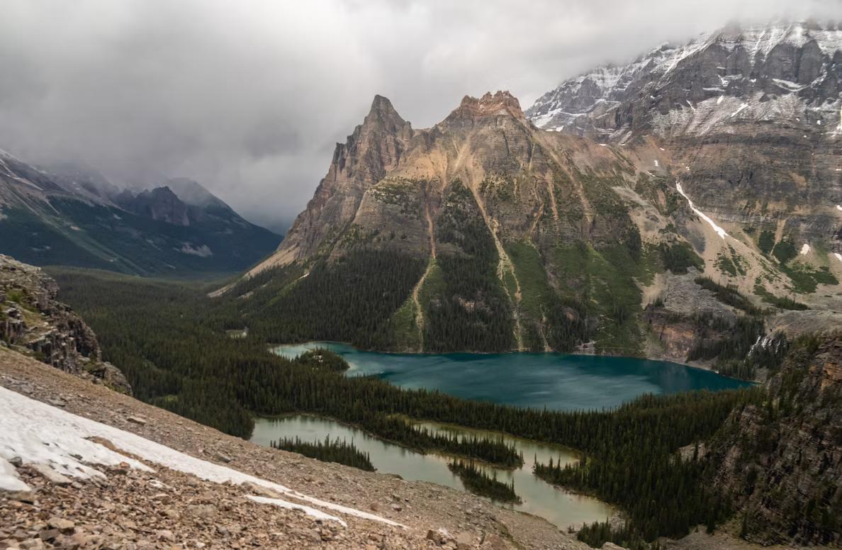
Lake O'Hara is deliberately hard to reach. Parks Canada limits access by running a shuttle bus with a reservation system that people set alarms for, and the alternative is an 11 kilometre walk up the access road. What that protects is the densest concentration of alpine scenery in Canada: a turquoise lake, a ring of peaks, and a network of hand-built trails climbing to Lake Oesa, Opabin Plateau and the Yukness Ledges. The full Alpine Circuit is about 12 kilometres and involves exposed ledge traverses with cables in places, so it is not the introduction to the area. Read the Parks Canada Lake O'Hara page carefully, then put the reservation opening date in your calendar for the following year.
7. The Berg Lake Trail, Mount Robson Provincial Park
Mount Robson is the highest peak in the Canadian Rockies at 3,954 metres, and the Berg Lake Trail walks you to a turquoise lake at its foot where a glacier calves icebergs into the water while you eat dinner. It is about 23 kilometres each way, with the Valley of a Thousand Falls section climbing steeply past Kinney Lake. Catastrophic flooding in 2021 destroyed large sections of the trail and it has been reopening in stages since, so the current status and the reservation process on the BC Parks Mount Robson page are the first thing to check rather than the last. Camping permits for the whole trail are competitive and released on a set date.
8. Mount Assiniboine Provincial Park
The Matterhorn of the Rockies sits on the BC side of the divide, and the classic approach is a 27 kilometre walk over Assiniboine Pass from the Mount Shark trailhead, carrying everything you need for several days. There is a helicopter that flies in on scheduled days, and there is no shame in taking it, though the walk in through Bryant Creek is part of the experience. Once you are at Lake Magog, the peak stands over the meadows like a stage set and you can spend three days on the Nub, the Niblet, Sunburst Lake and Wonder Pass without repeating a view. Book the campground, the Naiset huts or the lodge through the systems listed by BC Parks, and expect to plan this one the previous winter.
9. The West Coast Trail, Vancouver Island
Seventy-five kilometres of ladders, cable cars, bog, surge channels, sea stacks and beach walking between Pachena Bay and Gordon River, built as a shipwreck rescue route and now the most famous multi-day hike in Canada. Most people take six or seven days. The season runs roughly from May to the end of September, reservations open in January, and everyone attends a mandatory orientation before starting. Tides govern the beach sections, so you plan each day around a tide table rather than a distance. It rains. Your boots will not dry. You will also eat crab off a beach fire at Nitinaht Narrows and watch grey whales from a cliff, and you will be quietly insufferable about it for years. Start at Parks Canada's West Coast Trail page.
10. Mount Albert Edward, Strathcona Provincial Park
Vancouver Island's alpine is the province's most underrated, and Mount Albert Edward is the reason to find out. From Paradise Meadows the route runs about 32 kilometres return with 1,100 metres of gain, crossing subalpine meadows and passing Circlet Lake before a long open ridge walk to the summit at 2,093 metres. On a clear day you can see the Strait of Georgia on one side and the Comox Glacier on the other, with the mainland Coast Mountains standing up behind. Most people split it over two days by camping at Circlet Lake, which is also the sensible way to handle the weather on Strathcona Provincial Park's exposed ridges.
Planning the year around this list
If you want all ten, treat them as three seasons rather than one. Book Lake O'Hara, Berg Lake, Assiniboine and the West Coast Trail the winter before, because those four are decided by reservation systems and not by fitness. Keep Garibaldi and Wedgemount for July and August when the snow has gone from the ridges. Save Frosty for the last week of September and accept that the larches will make their own decision. The Chief and Joffre fill the gaps, and both are better at seven in the morning than at any other hour.
Practical points that apply to every trail here: the alpine holds snow far later than the trailhead suggests, cell coverage is absent almost everywhere on this list, and black bears are common on all of it while grizzlies are present at Assiniboine, Berg Lake and Lake O'Hara. Carry bear spray where it belongs and know how to use it. Check DriveBC before any drive on Highway 99, Highway 3 or the Island Highway, and use the Canooq pass and parking checker for day-use passes and reservation windows.
For the drives themselves, the scenic routes out of Vancouver overlap with half of these trailheads, and the rest of the Canooq travel guides cover where to sleep and eat at either end of a long day.
Sources
Related travel guides:
Page details
Author: Thomas Tremblay
Updated: August 13, 2026
Last reviewed: August 13, 2026
Sources verified: August 13, 2026
Cite this page: Canooq.ca, The BC Hikes Bucket List: 10 Trails Worth Planning a Year Around, https://www.canooq.ca/travel/bc-hikes-bucket-list
Canooq content is educational and may include affiliate or referral links. It is not financial, tax, legal, immigration, employment, mortgage, real estate, or healthcare advice. Verify official sources and provider terms before acting.
Enjoy Canooq? Let us keep helping you — make Canooq a preferred source on Google.