Canada's 22 UNESCO World Heritage Sites: A Complete Guide

July 15, 2026
All 22 of Canada's UNESCO World Heritage Sites, what makes each one significant, and practical tips on how to get there, what to explore, and what to know before you go.
What's on this page
All 22 of Canada's UNESCO World Heritage Sites, what makes each one significant, and practical tips on how to get there, what to explore, and what to know before you go.
Canada has 22 UNESCO World Heritage Sites, and together they cover almost everything the country is known for: Viking sod huts on a subarctic coast, the fossil beds where the first complex life on Earth appears in the rock, a walled French colonial city, buffalo jumps used for thousands of years, and mountain parks the size of small countries. Some are cultural, some are natural, and a few are both. Two of them straddle the border and are shared with the United States.
They are also spread across almost every province and territory, and the practical reality is that they range from a five-minute walk off a downtown street to a chartered floatplane into one of the most remote river valleys on the continent.
A quick note before the list: access, fees, reservation systems, and seasonal closures change often, especially for the national parks and fly-in sites. Confirm current details with Parks Canada before you embark on your next adventure.
1. L'Anse aux Meadows National Historic Site (1978)
Great Northern Peninsula, Newfoundland and Labrador
This is the only confirmed Norse settlement in North America, and the reason it matters is enormous: it is physical proof that Europeans reached the Americas around the year 1000, roughly five centuries before Columbus. Archaeologists uncovered the remains of timber-and-sod buildings and Norse artifacts here in the 1960s, and it was one of the first sites anywhere to make UNESCO's list in 1978.
- Getting there: Drive the Viking Trail (Route 430) to the northern tip of the Great Northern Peninsula. It is a long haul, roughly five to six hours from Deer Lake, which is the nearest airport. Most people pair it with Gros Morne on the same trip.
- What to explore: Walk through the reconstructed sod longhouses where costumed interpreters demonstrate Norse crafts and iron working. The interpretive centre lays out the archaeology clearly. Nearby Norstead is a separate reconstructed Viking village worth an hour.
- Good to know: The site is seasonal, generally open late spring through early autumn. Weather is raw and windy even in summer, so bring layers. Watch for moose on Route 430, particularly at dawn and dusk.
2. Nahanni National Park Reserve (1978)
Dehcho region, Northwest Territories
Nahanni protects the South Nahanni River as it carves through the Mackenzie Mountains, and its centrepiece is Náįlįcho (Virginia Falls), a thundering drop nearly twice the height of Niagara. The park is co-managed with the Dehcho First Nations, and the deep canyons, hot springs, and wild river make it one of the great wilderness destinations in the world.
- Getting there: There is no road. You reach Nahanni by chartered floatplane from Fort Simpson or Fort Liard, usually as part of a guided rafting or canoeing expedition or a scenic day flight.
- What to explore: Multi-day paddling trips down the South Nahanni are the classic experience, passing Virginia Falls and the towering walls of Fourth Canyon. Day flightseeing tours land at the falls if you have limited time.
- Good to know: This is a serious backcountry destination with a short summer season and a real budget attached to the air access. Book through a licensed outfitter and register with the park.
3. Dinosaur Provincial Park (1979)
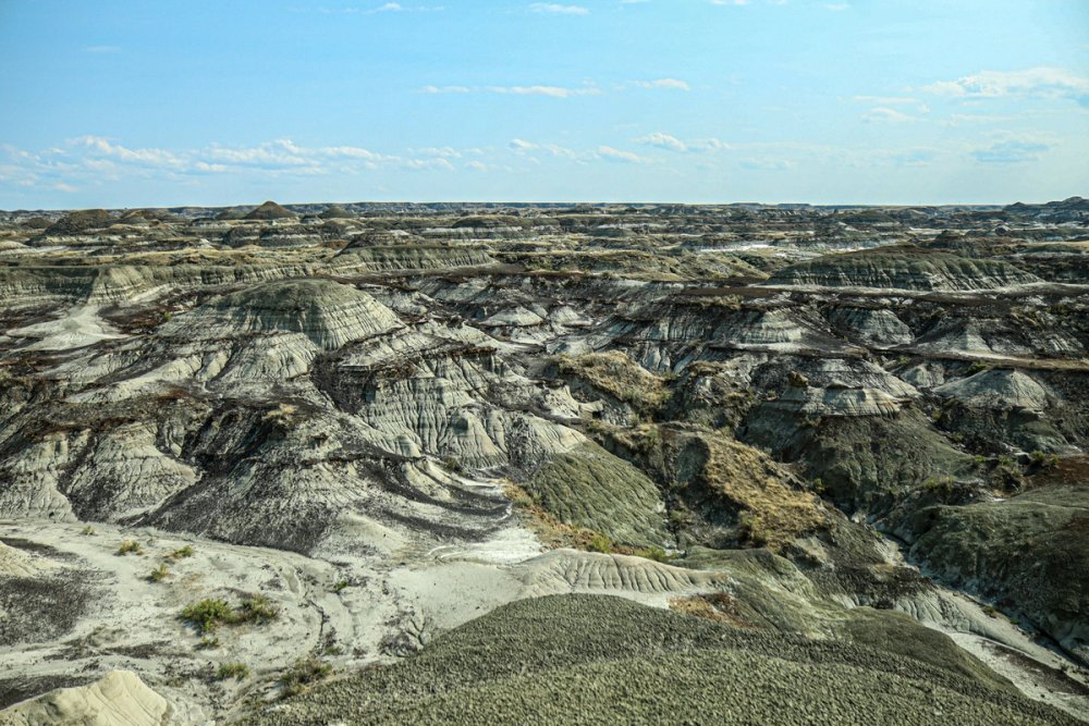
Badlands near Brooks, Alberta
Set in the eroded badlands of the Red Deer River valley, this park holds one of the richest dinosaur fossil records on Earth. More than 50 dinosaur species from the Late Cretaceous have been found here, and excavation continues today. The lunar-looking hoodoos and coulees are a landscape unlike anywhere else in the province.
- Getting there: Drive about two and a half hours east of Calgary, near the town of Brooks. A vehicle is essential.
- What to explore: Take a guided hike or bus tour into the restricted fossil zones, which you cannot enter on your own. The visitor centre has real specimens and fossil-prep labs. Camp overnight to catch the badlands at sunset.
- Good to know: Summer heat in the badlands is intense with little shade, so carry water. Guided programs sell out, so book ahead.
4. Kluane / Wrangell-St. Elias / Glacier Bay / Tatshenshini-Alsek (1979)
Yukon and British Columbia (shared with Alaska, USA)
This is a transboundary cluster of parks that together form one of the largest protected wilderness areas on the planet, spanning the Yukon, British Columbia, and Alaska. The Canadian side includes Kluane National Park, home to Mount Logan, Canada's highest peak, along with immense icefields and the largest non-polar glaciers on Earth.
- Getting there: Kluane is reachable by road from Whitehorse via the Alaska Highway, about a two-hour drive to Haines Junction. Tatshenshini-Alsek is remote and mostly accessed by river expedition.
- What to explore: Hike the front-country trails around Kathleen Lake and Haines Junction, or take a flightseeing tour over the icefields and Mount Logan, which is the only way to grasp the scale. Rafting the Alsek or Tatshenshini is a bucket-list wilderness trip.
- Good to know: The icefields are the main attraction but are only visible from the air or on serious backcountry routes. Grizzly country, so travel prepared.
5. SGang Gwaay (1981)
Haida Gwaii, British Columbia
On a small island at the southern end of Haida Gwaii stand the weathered remains of the Haida village of Nan Sdins, including the world's finest surviving collection of Haida mortuary and memorial poles, left standing where they were raised. It is a profoundly moving cultural site and a place of deep significance to the Haida Nation.
- Getting there: SGang Gwaay is deep inside Gwaii Haanas National Park Reserve, reached only by boat or floatplane, typically on a multi-day guided tour from Sandspit or Queen Charlotte.
- What to explore: Haida Gwaii Watchmen guide visitors through the village and share its history. The poles slowly returning to the forest are the point; this is not a restored museum piece.
- Good to know: Visitor numbers are limited and you must go with a licensed operator or hold a permit. The Gwaii Haanas orientation is mandatory.
6. Head-Smashed-In Buffalo Jump (1981)
Near Fort Macleod, Alberta
For nearly 6,000 years, Blackfoot peoples drove bison off this sandstone cliff in one of the most sophisticated communal hunting systems ever devised. The site preserves the drive lanes, the cliff, and the layers of bone below it, and it is one of the oldest and best-preserved buffalo jumps in North America.
- Getting there: Drive about 1 hour 45 minutes south of Calgary, near Fort Macleod. A car is needed.
- What to explore: The interpretive centre is built right into the cliff and tells the story from the Blackfoot perspective across several levels. Walk the trails along the top and bottom of the jump.
- Good to know: The name comes from a Blackfoot story, not a description of the bison. Check for Blackfoot cultural events and demonstrations when planning your date.
7. Wood Buffalo National Park (1983)
Alberta and Northwest Territories
Canada's largest national park protects vast boreal plains, the Peace-Athabasca Delta (one of the world's largest freshwater inland deltas), and the last wild nesting grounds of the endangered whooping crane. It also shelters the largest free-roaming wood bison herd on Earth and holds a Dark Sky Preserve designation.
- Getting there: Access is via Fort Smith on the NWT side or Fort Chipewyan in Alberta, which is fly-in or winter-road only. Fort Smith is reachable by road or air.
- What to explore: Look for bison along park roads near Fort Smith, visit the salt plains, and paddle sections of the delta. In winter, the dark skies deliver exceptional aurora viewing.
- Good to know: This is remote, buggy in summer, and services are limited. Plan fuel and supplies carefully.
8. Canadian Rocky Mountain Parks (1984)
Alberta and British Columbia
This is the big one for most travellers: a contiguous block of Banff, Jasper, Yoho, and Kootenay national parks plus Mount Robson, Mount Assiniboine, and Hamber provincial parks. UNESCO recognized the mountain landscapes, glaciers, and the Burgess Shale, a fossil bed that captured soft-bodied ocean life from over 500 million years ago in extraordinary detail.
- Getting there: Calgary is the main gateway, about 1.5 hours to Banff. The parks are connected by the Trans-Canada Highway and the Icefields Parkway.
- What to explore: Lake Louise and Moraine Lake, the Icefields Parkway, and Yoho's Takakkaw Falls are the headliners. Serious hikers can book a guided trek to the Burgess Shale fossil sites. Mount Assiniboine is a backcountry gem.
- Good to know: Moraine Lake no longer allows private vehicles; use the shuttle or a tour. Summer crowds are heavy, so start early and reserve parking and campsites well ahead.
9. Historic District of Old Québec (1985)
Québec City, Quebec
Old Québec is the only fortified city north of Mexico with its walls still intact, and it is the cradle of French civilization in North America. Founded in 1608, its Upper and Lower Towns preserve a dense, remarkably authentic streetscape of stone buildings, ramparts, and squares crowned by the iconic Château Frontenac.
- Getting there: Québec City has its own airport and VIA Rail station, and the old town is a compact, walkable district. You do not want a car inside the walls.
- What to explore: Walk the ramparts, wander Petit-Champlain and Place Royale in the Lower Town, and take the funicular between levels. The Plains of Abraham and the Citadelle round out the history.
- Good to know: It is genuinely lived-in and busy year-round; winter, with Carnaval and snow on the rooftops, is arguably the most atmospheric time.
10. Gros Morne National Park (1987)
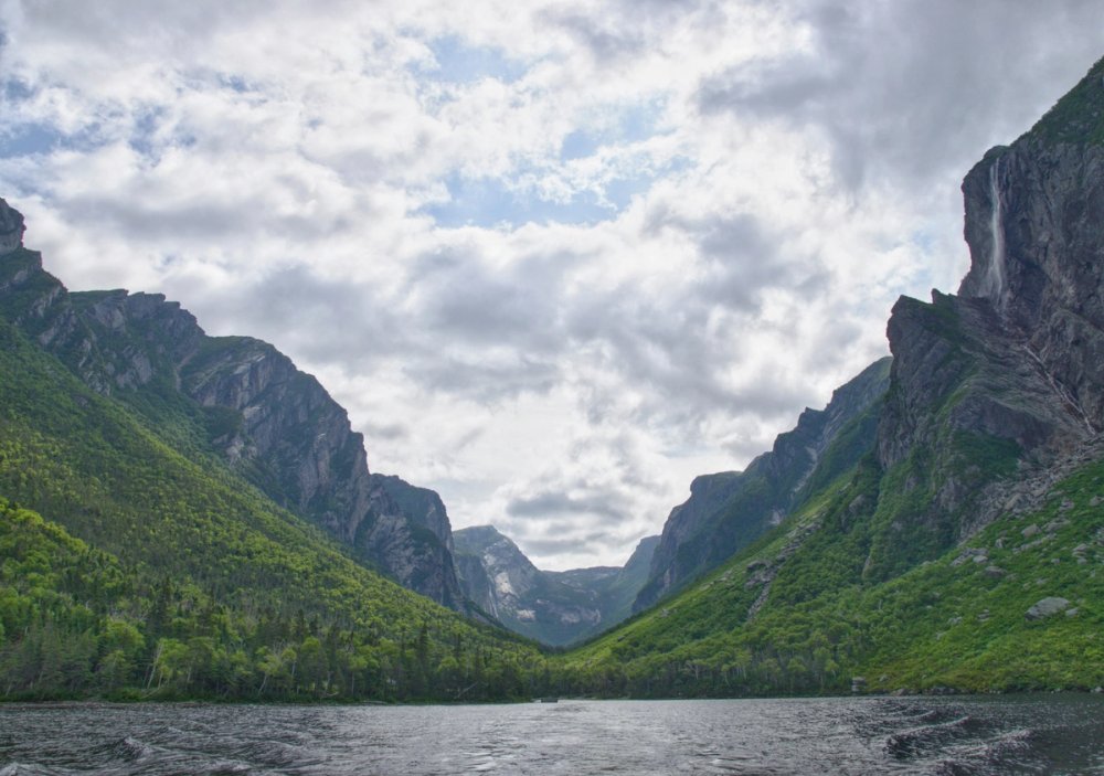
Western Newfoundland
Gros Morne is a geologist's dream and a hiker's paradise. Its Tablelands expose the Earth's mantle at the surface, rock that normally sits kilometres underground, offering visible proof of plate tectonics. Glacier-carved fjords, coastal bogs, and the flat-topped Gros Morne mountain complete a landscape of global scientific value.
- Getting there: Fly into Deer Lake and drive 30 to 60 minutes into the park. A car is essential.
- What to explore: Book the Western Brook Pond boat tour through a landlocked fjord walled by 600-metre cliffs. Hike the barren, orange Tablelands, and if you are fit, the long climb up Gros Morne mountain.
- Good to know: The Western Brook Pond boat requires an advance booking plus a 3-kilometre walk to the dock. Weather is changeable; pack for wind and rain even in July.
11. Old Town Lunenburg (1995)
South Shore, Nova Scotia
Lunenburg is the best surviving example of a planned British colonial settlement in North America, laid out on a strict grid in 1753 and still intact today. Its brightly painted waterfront and wooden architecture reflect centuries of shipbuilding and the Atlantic fishery, and it remains a working port.
- Getting there: Drive about an hour southwest of Halifax along the South Shore. Easy day trip or overnight.
- What to explore: Wander the colourful waterfront, tour the Fisheries Museum of the Atlantic, and look for the Bluenose II schooner when it is in port. The surrounding villages of Mahone Bay and Blue Rocks are close by.
- Good to know: Parking in the compact old town fills up midday in summer. Come early or stay the night to enjoy it after the day crowds leave.
12. Waterton Glacier International Peace Park (1995)
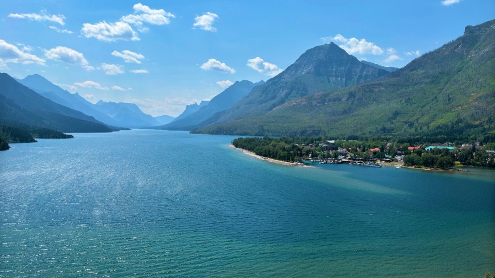
Alberta (shared with Montana, USA)
This was the world's first International Peace Park, created in 1932 by joining Canada's Waterton Lakes National Park with Glacier National Park in Montana. UNESCO recognized it for both the symbolism of cross-border cooperation and the spot where prairie meets mountain, producing exceptional biodiversity.
- Getting there: Drive roughly 2.5 to 3 hours south of Calgary. The Canadian side centres on Waterton townsite.
- What to explore: Take the boat cruise down Upper Waterton Lake, which crosses into the United States. Hike to Bertha Lake or Crypt Lake, one of the most dramatic day hikes in the Rockies, reached by a small ferry.
- Good to know: Crossing to the Montana side by boat or road requires a passport. Wildfires have affected the area in recent years, so check trail conditions.
13. Miguasha National Park (1999)
Gaspé Peninsula, Quebec
This coastal cliff on the Gaspé Peninsula is the world's most important fossil site for understanding the Devonian "Age of Fishes," roughly 380 million years ago. It is especially significant for its lobe-finned fishes, the group that gave rise to the first four-legged land animals, making it central to the story of how life left the water.
- Getting there: Drive along the Gaspé coast; it is remote, several hours from the nearest cities, and best folded into a wider Gaspésie road trip.
- What to explore: The natural history museum displays superbly preserved fossils, and guided walks along the cliff show you where they are still eroding out of the rock.
- Good to know: Seasonal operation, roughly June through October. It is small and easily seen in a couple of hours.
14. Rideau Canal (2007)
Ottawa to Kingston, Ontario
The Rideau Canal is the oldest continuously operated canal system in North America, opened in 1832 and still running with much of its original hand-operated lock machinery. Built for military reasons after the War of 1812, it links Ottawa to Kingston across 202 kilometres of canal, rivers, and lakes.
- Getting there: The canal threads right through downtown Ottawa, and points along it are easily reached by road. Kingston anchors the southern end.
- What to explore: Watch the hand-cranked locks operate below Parliament Hill in Ottawa, cruise a section by boat, or cycle the pathways. In winter, a stretch in Ottawa becomes the Rideau Canal Skateway, one of the largest skating rinks in the world.
- Good to know: The skateway only opens when ice is thick enough, and warm winters have shortened or cancelled recent seasons. Check the daily ice report.
15. Joggins Fossil Cliffs (2008)
Bay of Fundy, Nova Scotia
The world's highest tides at the Bay of Fundy constantly erode these cliffs, exposing the most complete fossil record of life in the "Coal Age" some 300 million years ago. Joggins is famous for fossil trees still standing upright where they grew, and for the earliest known reptiles, ancestors of everything that later lived fully on land.
- Getting there: Drive about an hour from Amherst in northern Nova Scotia. A car is needed.
- What to explore: Take a guided beach walk timed to the tides to see fossils in the cliff face, including the upright tree trunks. The interpretive centre sits at the top of the cliffs.
- Good to know: The Fundy tides are dangerous and fast; only go onto the beach with a guide or a solid tide table. New fossils appear after every storm.
16. Landscape of Grand Pré (2012)
Annapolis Valley, Nova Scotia
Grand Pré is a cultural landscape of farmland reclaimed from the sea by Acadian settlers using an ingenious system of dykes, or aboiteaux, some still in use today. It is also the emotional heart of Acadian memory, the site from which the British deported the Acadian people in 1755, and a place of pilgrimage for Acadians worldwide.
- Getting there: Drive about an hour from Halifax into the Annapolis Valley. Combine with wine touring in the valley.
- What to explore: Visit the memorial church and gardens, learn the dyke-building story at the interpretive centre, and look out over the reclaimed marshlands that the dykes still protect.
- Good to know: The significance here is as much human as scenic. Reading a little Acadian history first makes the visit far richer.
17. Red Bay Basque Whaling Station (2013)
Labrador
In the 16th century, Basque mariners crossed the Atlantic to hunt whales here, and Red Bay preserves the best-documented evidence of that early industrial whaling. Archaeologists found try-works for rendering blubber, cooperages, a cemetery, and even sunken whaling ships in the harbour, revealing one of the earliest European industrial operations in the Americas.
- Getting there: This is remote Labrador. Reach it via the ferry from Newfoundland's Northern Peninsula to Labrador, then drive north. It rewards travellers already exploring the region.
- What to explore: The interpretive centre displays a nearly complete whaling shallop and Basque artifacts. A short boat trip and trail lead to Saddle Island, where the try-works and cemetery lie.
- Good to know: Very seasonal and weather-dependent. Confirm ferry schedules well in advance, as they drive the whole itinerary.
18. Mistaken Point (2016)
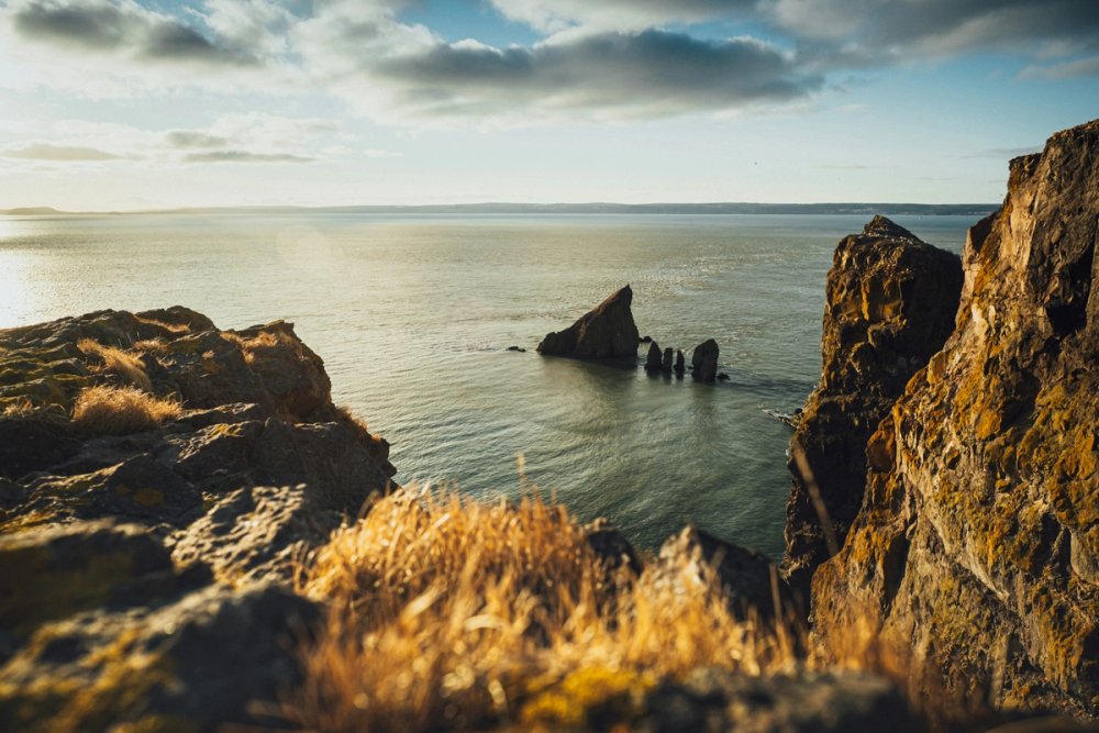
Avalon Peninsula, Newfoundland and Labrador
The sea cliffs at Mistaken Point hold the oldest known fossils of large, complex multicellular life on Earth, dating to roughly 565 million years ago. These Ediacaran creatures, preserved by volcanic ash on ancient seafloors, capture the moment life first grew big, before the appearance of animals as we know them.
- Getting there: Drive about two hours south of St. John's to the ecological reserve on the Avalon Peninsula.
- What to explore: Access to the fossil surfaces is only by guided hike, a roughly 3-kilometre walk each way over open, often foggy barrens. Guides have you remove your shoes to protect the delicate impressions.
- Good to know: Tours are limited, weather-dependent, and must be booked; the fossil beds cannot be visited on your own. Reserve ahead in the short summer season.
19. Pimachiowin Aki (2018)
Manitoba and Ontario
Pimachiowin Aki, meaning "the land that gives life" in Anishinaabemowin, was Canada's first mixed natural-and-cultural World Heritage Site. It protects a vast tract of boreal forest that is the ancestral home of Anishinaabe communities, recognized both for its intact ecosystems and for the living Indigenous tradition of caring for the land.
- Getting there: This is deep wilderness on the Manitoba-Ontario border. Most access is by float plane or boat through partnering First Nations communities such as Bloodvein River and Poplar River.
- What to explore: Visits are community-led and focus on the land, the rivers, and Anishinaabe knowledge rather than built attractions. Fishing, paddling, and cultural interpretation are the draws.
- Good to know: Plan through the communities themselves; this is not a drive-up park. Trip logistics and cost are significant.
20. Writing-on-Stone / Áísínai'pi (2019)
Milk River valley, Alberta
Along the Milk River, sandstone hoodoos hold the largest concentration of Indigenous rock art on the North American plains. For the Blackfoot, Áísínai'pi is a sacred place where the petroglyphs and pictographs record ceremony, history, and the presence of spiritual beings across thousands of years.
- Getting there: Drive roughly 3.5 hours southeast of Calgary, near the Montana border. A car is required.
- What to explore: The interpretive centre frames the Blackfoot significance, and guided tours take you into the protected rock-art areas you cannot enter alone. Camp among the hoodoos to see them at golden hour.
- Good to know: This is a sacred site, not a photo backdrop; follow the guides' protocols. Summer is hot and exposed.
21. Anticosti (2023)
Gulf of St. Lawrence, Quebec
This large island in the Gulf of St. Lawrence preserves the world's best fossil record of the first mass extinction, the Ordovician-Silurian event around 445 million years ago that wiped out much of marine life. Layer upon layer of exceptionally clear fossil-bearing rock makes it a global reference point for paleontologists.
- Getting there: Anticosti is reached by small plane or seasonal ferry from the Quebec mainland. It is sparsely populated, with the village of Port-Menier as its hub.
- What to explore: Fossil-rich riverbeds, canyons, waterfalls, and one of the densest deer populations anywhere. The island is largely a vast nature reserve.
- Good to know: Infrastructure is minimal and distances are large; most visitors come for hunting, fishing, or organized nature trips. Plan transport and lodging well ahead.
22. Tr'ondëk-Klondike (2023)
Dawson City area, Yukon
This site along the Yukon River tells two intertwined stories: the homeland of the Tr'ondëk Hwëch'in people and the upheaval of the Klondike Gold Rush that reshaped their world after 1896. It preserves fishing camps, settlement sites, and the meeting of Indigenous life with one of history's great gold rushes.
- Getting there: Drive the Klondike Highway from Whitehorse to Dawson City, about six hours, or fly into Dawson. Dawson City is the base for the site.
- What to explore: Dawson's gold-rush streetscape, the Tr'ondëk Hwëch'in cultural centre, and interpretive sites like Tr'ochëk at the mouth of the Klondike River. Pan for gold or ride a dredge tour nearby.
- Good to know: Summer is the season; Dawson is quiet and cold in winter. The Midnight Dome above town gives you the whole river valley at once.
Planning your visits: what applies across the board
A few things are worth knowing before you build any of these into a trip.
Most of the natural sites sit inside national parks, so a Parks Canada pass covers entry, and an annual Discovery Pass pays off quickly if you are visiting several in a year. Reservation systems now govern the busiest places, including parking at Moraine Lake and guided access to fossil sites like Mistaken Point, the Burgess Shale, and Writing-on-Stone. If a site requires a guide, that is not an upsell; for the fragile fossil and rock-art sites it is the only legal way in, and it exists to protect them.
The remote sites are a different kind of trip. Nahanni, SGang Gwaay, Pimachiowin Aki, Wood Buffalo, and parts of the Kluane cluster involve float planes, boats, or expedition outfitters, short summer windows, and real budgets. Book those through licensed operators months ahead. For the many sites tied to Indigenous history and living cultures, from Head-Smashed-In to Tr'ondëk-Klondike, go in ready to listen; the interpretation from the communities themselves is the best part of the visit.
Finally, geography clusters these sites in ways that make natural itineraries. Newfoundland alone holds four (L'Anse aux Meadows, Gros Morne, Red Bay, and Mistaken Point). Nova Scotia holds four more (Lunenburg, Joggins, Grand Pré, and its share of Fundy). Southern Alberta packs in five within a few hours' drive. Planning around a region rather than chasing single sites across the country will save you a lot of driving and flying.
Bottom line
The UNESCO World Heritage Sites highlight our deep geological past, the long presence of Indigenous peoples, the arrival of Norse and then French and British settlers, and landscapes big enough to lose yourself in.
Related travel guides:
Page details
Author: Thomas Tremblay
Updated: August 7, 2026
Cite this page: Canooq.ca, Canada's 22 UNESCO World Heritage Sites: A Complete Guide, https://www.canooq.ca/travel/canada-unesco-world-heritage-sites
Canooq content is educational and may include affiliate or referral links. It is not financial, tax, legal, immigration, employment, mortgage, real estate, or healthcare advice. Verify official sources and provider terms before acting.
Enjoy Canooq? Let us keep helping you — make Canooq a preferred source on Google.